IMAGES TAKEN NEAR TO
Dewars Lane, BERWICK-UPON-TWEED, TD15 1HJ
Introduction
This page details the photographs taken nearby to Dewars Lane, TD15 1HJ by members of the Geograph project.
The Geograph project started in 2005 with the aim of publishing, organising and preserving representative images for every square kilometre of Great Britain, Ireland and the Isle of Man.

There are currently over 7.5m images from over14,400 individuals and you can help contribute to the project by visiting https://www.geograph.org.uk
Image Map
Images are licensed for reuse under creativecommons.org/licenses/by-sa/2.0
Notes
- Clicking on the map will re-center to the selected point.
- The higher the marker number, the further away the image location is from the centre of the postcode.
Image Listing (1565 Images Found)
Images are licensed for reuse under creativecommons.org/licenses/by-sa/2.0
Image
Details
Distance
1
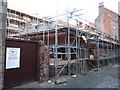
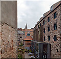
Building continues at Dewar's Lane Granary
Updated view of the building-work as seen from Sallyport - see Image
Image: © Barbara Carr
Taken: 19 May 2009
0.00 miles
2
Dewar's Lane, Berwick-upon-Tweed
This is the subject of a drawing by LS Lowry, who used to holiday in Berwick. See https://www.artfund.org/supporting-museums/art-weve-helped-buy/artwork/5484/dewars-lane-berwick-upon-tweed
The building on the right with the leaning wall is the old granary, which is now a Youth Hostel. It is a Grade II Listed Building. See https://historicengland.org.uk/listing/the-list/list-entry/1072607
Image: © Ian Taylor
Taken: 15 Feb 2019
0.00 miles
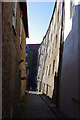
3
Sallyport, Berwick upon Tweed
Sallyport links Bridge Street to the Quayside. The arch at the end of the lane (partly obscured by the metal fence around the building-works in progress at Dewar's Lane Granary) is the opening to a low, narrow tunnel under the Town Walls, which curves so that one cannot see from one end to the other: thus it is dark even at noon, and so provided cover for soldiers guarding the harbour from any attack from the Quayside. Steps to the left of the arch give access to the walkway around the Walls. The information board on the right is part of the Lowry trail round Berwick and Tweedmouth, showing the artist's interpretation of Sallyport.
Image: © Barbara Carr
Taken: 7 Apr 2009
0.01 miles
4
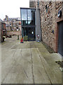
All rails lead to Berwick Youth Hostel
Dewars Lane Granary was built in 1769. An 18-inch gauge railway linked the Granary through an opening in the Quay Wall direct to the Quayside. These tracks set in the surface of the courtyard appear to roughly follow the original alignments.
In recent years, this grade 2 listed building has been restored and converted to house Berwick Youth Hostel and an Art Gallery and was reopened in 2011.
Image: © Oliver Dixon
Taken: 11 Oct 2015
0.01 miles
5
Back of buildings on Dewar's Lane, Berwick
Image: © habiloid
Taken: 19 Aug 2020
0.01 miles
6

Dewar's Granary development grows
Building progress, cf Image]
Image: © Barbara Carr
Taken: 7 Apr 2009
0.01 miles
7
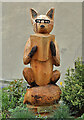
A wooden fox sculpture
This sculpture in Bridge Street, Berwick-upon-Tweed is dedicated to Dr Simon Heald. Fork handles is carved on the book spine and four candles on the cover, which is a reference to a Two Ronnies TV sketch. A small plaque is inscribed:
To celebrate the life of
Dr Simon Heald
Proprietor of Slightly Foxed
Bookshop, 31 Bridge Street
“Have a great day, my lovelies…”
Image: © Walter Baxter
Taken: 27 May 2021
0.01 miles
8
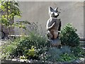
Wooden Fox Sculpture in Berwick on Tweed
This wooden fox stands in Bridge Street Berwick. He is dedicated to Dr Simon Heald, who died in 2020, proprietor of Slightly Foxed bookshop nearby. The book fox is reading is called Fork Handles and has four candles on its front cover. This refers to a TV sketch by the Two Ronnies.
Image: © Jennifer Petrie
Taken: 1 Sep 2023
0.01 miles
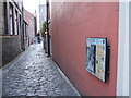
9
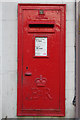
Elizabeth II Postbox, Bridge Street
Near the junction with Dewar's Lane.
Image: © Mark Anderson
Taken: 2 Sep 2009
0.01 miles
10
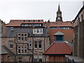
Berwick rooftops
Looking from the ramparts towards the Town Hall.
Image: © Stephen Craven
Taken: 5 Aug 2017
0.01 miles