IMAGES TAKEN NEAR TO
GALASHIELS, TD1 2QD
Introduction
This page details the photographs taken nearby to TD1 2QD by members of the Geograph project.
The Geograph project started in 2005 with the aim of publishing, organising and preserving representative images for every square kilometre of Great Britain, Ireland and the Isle of Man.

There are currently over 7.5m images from over14,400 individuals and you can help contribute to the project by visiting https://www.geograph.org.uk
Image Map
Images are licensed for reuse under creativecommons.org/licenses/by-sa/2.0
Notes
- Clicking on the map will re-center to the selected point.
- The higher the marker number, the further away the image location is from the centre of the postcode.
Image Listing (3 Images Found)
Images are licensed for reuse under creativecommons.org/licenses/by-sa/2.0
Image
Details
Distance
1
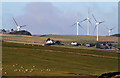
Hawksnest Farm
This long telephoto shot was taken from the hillside near Arenel Moss, northwest of Wester Housebyres. The turbines are at Longpark Wind Farm.
Image: © Walter Baxter
Taken: 1 Jan 2013
0.04 miles
2
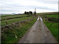
Lane, Hawksnest
Taken just past the farm. The road is still shown in yellow on the map here, but is unsurfaced. Eildon Hills in the background.
Image: © Richard Webb
Taken: 7 Oct 2006
0.07 miles
3
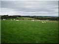
Hawksnest
Cheviot sheep in the very open pastures between Wooplaw and Hawksnest.
Image: © Richard Webb
Taken: 7 Oct 2006
0.14 miles