IMAGES TAKEN NEAR TO
GALASHIELS, TD1 2QA
Introduction
This page details the photographs taken nearby to TD1 2QA by members of the Geograph project.
The Geograph project started in 2005 with the aim of publishing, organising and preserving representative images for every square kilometre of Great Britain, Ireland and the Isle of Man.

There are currently over 7.5m images from over14,400 individuals and you can help contribute to the project by visiting https://www.geograph.org.uk
Image Map (Loading...)


Getting Data...Please wait
Leaflet Map data © OpenStreetMap
Images are licensed for reuse under creativecommons.org/licenses/by-sa/2.0
Notes
- Clicking on the map will re-center to the selected point.
- The higher the marker number, the further away the image location is from the centre of the postcode.
Image Listing (17 Images Found)
Images are licensed for reuse under creativecommons.org/licenses/by-sa/2.0
Image
Details
Distance
1

Sign at the entrance to Axehead Wood
Axehead Wood is a community project at Wooplaw
Image: © James Denham
Taken: 7 May 2008
0.04 miles
2

Field at Wooplaw
Looking south. Not sure what the 'rugby' posts might be - no cross bar, not an ideal field for rugby, and not a matching pair in the field.
Image: © M J Richardson
Taken: 11 Oct 2014
0.06 miles
3
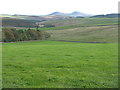
View from Wooplaw
Looking southeast towards the Eildon Hills, 11km away.
Image: © M J Richardson
Taken: 11 Oct 2014
0.06 miles
5
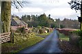
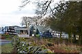
Road east of Wooplaw
The road meets the Langlee to Lauder road about 1km E of here.
Image: © Jim Barton
Taken: 22 Dec 2019
0.07 miles
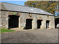
6
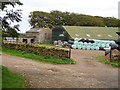
Wooplaw farm
Farmhouse and buildings, with silage bales.
Image: © M J Richardson
Taken: 11 Oct 2014
0.08 miles
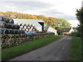
8
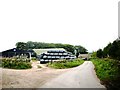
Wooplaw farm
The name comes from the Norse 'uplaw' meaning a shallow valley at the top of a hill (from the information board at the Community Woodland). It is certainly on top of a hill as the land here is around 310m.
Image: © Jim Barton
Taken: 22 Dec 2019
0.10 miles
9
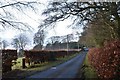
Road to Stow, Wooplaw
The minor road through farmland bordering Longpark windfarm.
Image: © Jim Barton
Taken: 22 Dec 2019
0.11 miles
10
Wooplaw Farm.
Situated on minor road between Stow and Blainslie in the Scottish Borders.
Image: © James Denham
Taken: 23 Sep 2008
0.15 miles