IMAGES TAKEN NEAR TO
Lintburn Street, GALASHIELS, TD1 1HR
Introduction
This page details the photographs taken nearby to Lintburn Street, TD1 1HR by members of the Geograph project.
The Geograph project started in 2005 with the aim of publishing, organising and preserving representative images for every square kilometre of Great Britain, Ireland and the Isle of Man.

There are currently over 7.5m images from over14,400 individuals and you can help contribute to the project by visiting https://www.geograph.org.uk
Image Map (Loading...)


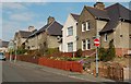
Getting Data...Please wait
Leaflet Map data © OpenStreetMap
Images are licensed for reuse under creativecommons.org/licenses/by-sa/2.0
Notes
- Clicking on the map will re-center to the selected point.
- The higher the marker number, the further away the image location is from the centre of the postcode.
Image Listing (261 Images Found)
Images are licensed for reuse under creativecommons.org/licenses/by-sa/2.0
Image
Details
Distance
1
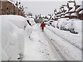
Meigle Street, Galashiels
Most of the UK has had some snow in the past few days. Over 2 feet (60cm) has fallen in the town causing problems for car drivers and pedestrians.
Image: © Walter Baxter
Taken: 2 Dec 2010
0.05 miles
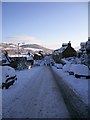
3
Gala Park, Galashiels
Traditional pitched roof houses like those on the left were pulled down and replaced with these flats in the early 1970s.
Image: © Walter Baxter
Taken: 18 Jul 2007
0.05 miles
4
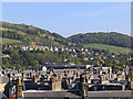
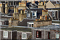
Galashiels roofscape
A mixture of roof types in Thistle Street, Meigle Street, Lintburn Street, Scott Street and Gala Park, viewed from Eildon Street on the southwest side of the town. A recent housing scheme on Blaikie's Hill is centre left in the background and the field to the right below the mast on Wester Hill, is zoned for future housing. The small white blob on the hillside on the upper left is a protest sign about the Tesco superstore development in the town, but I doubt if many folk will see that up there. See Image
Image: © Walter Baxter
Taken: 10 Oct 2007
0.07 miles
5
Dormer windows and chimneys
This telephoto shot from Eildon Street in Galashiels has compressed the roofscape in the town.
Image: © Walter Baxter
Taken: 30 May 2016
0.07 miles
6
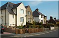
Balmoral Avenue, Galashiels
Post-war council housing in Balmoral Avenue. A lot of these properties, substantial buildings with good-sized gardens, have been purchased under the Right To Buy scheme.
Image: © Mary and Angus Hogg
Taken: 13 Apr 2009
0.07 miles
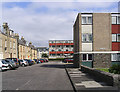
7
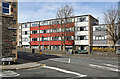
The junction of Balmoral Place and Scott Street, Galashiels
The flats opposite replaced traditional whinstone houses.
Image: © Walter Baxter
Taken: 4 Apr 2017
0.08 miles
9
Forest Gardens
The bottom end of Forest Gardens, in Galashiels. This council housing area was built shortly after the Second World War, long before car ownership had become common. This street has now been made 1-way to allow for roadside parking without restricting the flow of traffic.
Image: © Mary and Angus Hogg
Taken: 13 Apr 2009
0.08 miles
10
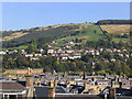
Roof tops in Galashiels
Viewed from Eildon Street on the southwest side of the town, this shows various roofs on houses in Thistle Street, Victoria Street, Lintburn Street and Gala Park. The houses beyond were built in the 1980s on the former Ladhope Estate. The building in the background centre left is the clubhouse for Galashiels Golf Course, see Image The course is very hilly, especially the second nine holes, as can be appreciated by the 10th hole going up by the wall on the right. Hard on the lungs going up and hard on the knees coming down, but the views from the top on a good day are worth the effort.
Image: © Walter Baxter
Taken: 10 Oct 2007
0.08 miles