IMAGES TAKEN NEAR TO
DUNS, TD11 3LE
Introduction
This page details the photographs taken nearby to TD11 3LE by members of the Geograph project.
The Geograph project started in 2005 with the aim of publishing, organising and preserving representative images for every square kilometre of Great Britain, Ireland and the Isle of Man.

There are currently over 7.5m images from over14,400 individuals and you can help contribute to the project by visiting https://www.geograph.org.uk
Image Map
Images are licensed for reuse under creativecommons.org/licenses/by-sa/2.0
Notes
- Clicking on the map will re-center to the selected point.
- The higher the marker number, the further away the image location is from the centre of the postcode.
Image Listing (6 Images Found)
Images are licensed for reuse under creativecommons.org/licenses/by-sa/2.0
Image
Details
Distance
1
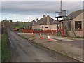
Edington Mains weighbridge
Large crates for shipping potatoes are stacked in adjacent farm buildings. Edington Mains appears to specialise in potato farming and this may explain the need for a weighbridge.
Image: © Graham Barnes
Taken: 27 Jan 2007
0.09 miles
2
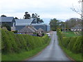
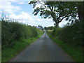
Down the hill to Mains
Mains Farm, on the minor road to Edington and its Mill.
Image: © Barbara Carr
Taken: 11 May 2013
0.11 miles
4
Minor road towards Edington Mill
Looking south.
Image: © JThomas
Taken: 27 Jul 2017
0.18 miles
5
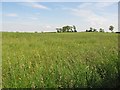
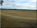
Oilseed rape, Edington
Midsummer and flowering has now finished.
Image: © Richard Webb
Taken: 22 Jun 2010
0.19 miles