IMAGES TAKEN NEAR TO
Yarrow, HIGHBRIDGE, TA9 4LN
Introduction
This page details the photographs taken nearby to Yarrow, TA9 4LN by members of the Geograph project.
The Geograph project started in 2005 with the aim of publishing, organising and preserving representative images for every square kilometre of Great Britain, Ireland and the Isle of Man.

There are currently over 7.5m images from over14,400 individuals and you can help contribute to the project by visiting https://www.geograph.org.uk
Image Map
Images are licensed for reuse under creativecommons.org/licenses/by-sa/2.0
Notes
- Clicking on the map will re-center to the selected point.
- The higher the marker number, the further away the image location is from the centre of the postcode.
Image Listing (11 Images Found)
Images are licensed for reuse under creativecommons.org/licenses/by-sa/2.0
Image
Details
Distance
1
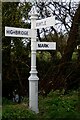
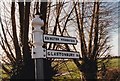
Direction Sign ? Signpost on Mark Moor
Located on the northeast side of the junction of Southwick Road, Yarrow Road and River Road in Mark parish. 3 arms and pyramid finial. See also http://www.flickr.com/photos/13171205@N08/8370995757 before it was restored.
Milestone Society National ID: SO_ST3746
Image: © R Raynsford
Taken: 31 Oct 2020
0.04 miles
2
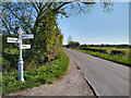
Road Sign near Mark
Road sign at a crossroads on Southwick Road near Mark, looking east. The north unsigned turning is onto Green Drove, a gravel drove, and the south turning signposted to Burtle is onto River Road.
Image: © Kevin Pearson
Taken: 25 Apr 2021
0.04 miles
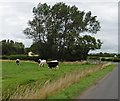
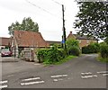
4
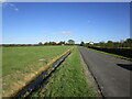
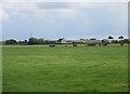
Lane between Southwick and Yarrow
Looking towards Yarrow. Moorhouse Farm on the right.
Image: © Jonathan Thacker
Taken: 10 Oct 2022
0.15 miles
6
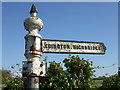
To Edington Highbridge
An old road signpost, flaking and cracked, on the Yarrow Road. Three other arms of the sign have been broken off, sadly. Edington is some 4km south.
Image: © Neil Owen
Taken: 11 May 2019
0.22 miles
8
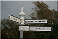
Direction Sign ? Signpost
Located on the southeast side of the T junction of Yarrow Road and Southwick Road in Yarrow in Mark parish. 2 arms and narrow cone on ball finial. The Glastonbury arm was missing by 2013, see http://www.flickr.com/photos/13171205@N08/8372068162. See also https://www.geograph.org.uk/photo/6153883.
Milestone Society National ID: SO_ST3846
Image: © W Marsh
Taken: Unknown
0.23 miles
9
Direction Sign ? Signpost in Yarrow
Located on the southeast side of the T junction of Yarrow Road and Southwick Road in Yarrow, Mark parish. As restored in 2020 with 3 arms and narrow cone on ball finial. See also with just one arm in 2019 https://www.geograph.org.uk/photo/6153883 and 2007 http://www.flickr.com/photos/13171205@N08/8372068162, and with two arms in 1996 https://www.geograph.org.uk/photo/6592604.
Milestone Society National ID: SO_ST3846
Image: © R Raynsford
Taken: 31 Oct 2020
0.23 miles