IMAGES TAKEN NEAR TO
Laurel Avenue, HIGHBRIDGE, TA9 4BD
Introduction
This page details the photographs taken nearby to Laurel Avenue, TA9 4BD by members of the Geograph project.
The Geograph project started in 2005 with the aim of publishing, organising and preserving representative images for every square kilometre of Great Britain, Ireland and the Isle of Man.

There are currently over 7.5m images from over14,400 individuals and you can help contribute to the project by visiting https://www.geograph.org.uk
Image Map
Images are licensed for reuse under creativecommons.org/licenses/by-sa/2.0
Notes
- Clicking on the map will re-center to the selected point.
- The higher the marker number, the further away the image location is from the centre of the postcode.
Image Listing (91 Images Found)
Images are licensed for reuse under creativecommons.org/licenses/by-sa/2.0
Image
Details
Distance
1
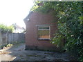
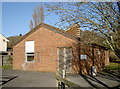
Former Telephone Exchange, Brent Knoll
Situated in Brent Street TA9 4BB, this redbrick building was replaced by a modern TE a short distance away in the early 1980s, http://www.geograph.org.uk/photo/2615001 refers.
Image: © David Hillas
Taken: 29 Sep 2011
0.03 miles
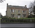
3
Ivyclad Hall
With a distinct lack of Ivy. An 18C Grade II listed building.
According to their website the railings also have a listed status.
Image: © Anthony Vosper
Taken: 7 Apr 2018
0.06 miles
4
Footpath to Applewithy Rhyne
Viewed from a slightly different angle from Image taken 14 months earlier.
Image: © Anthony Vosper
Taken: 7 Apr 2018
0.07 miles
5
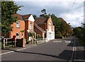
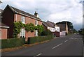
Brent Street, Brent Knoll
Almost the whole 6 kilometre circumference of Brent Knoll (the hill) is followed by a line of buildings at the edge of the surrounding levels; the most continuous development is here in Brent Knoll (the village) on the southwest side. The post box is TA9 71.
Image: © Derek Harper
Taken: 23 Sep 2010
0.07 miles
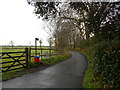
6
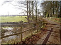
To Applewithy Rhyne
The footpath carries along the short road.
Image: © Neil Owen
Taken: 5 Jan 2017
0.07 miles
7
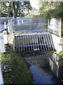
Grating on Church Lane
The area around the foothills of Brent Knoll are very low-lying and have many small rhynes to deal with.
Image: © Neil Owen
Taken: 5 Jan 2017
0.08 miles
8
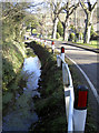
Don't go left!
Church Lane has a rhyne running alongside the road, but with little real protection from wayward travellers.
Image: © Neil Owen
Taken: 5 Jan 2017
0.09 miles
9
All mod telecomms
An interesting detail of this telephone exchange - a kitchen area!
Image: © Neil Owen
Taken: 5 Jan 2017
0.09 miles
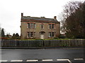
10
Brent Street, Brent Knoll
The group of buildings includes Image, which dates from 1837, and is just southeast of the junction with Church Lane.
Image: © Derek Harper
Taken: 23 Sep 2010
0.10 miles