IMAGES TAKEN NEAR TO
Toomer Close, HIGHBRIDGE, TA9 4AE
Introduction
This page details the photographs taken nearby to Toomer Close, TA9 4AE by members of the Geograph project.
The Geograph project started in 2005 with the aim of publishing, organising and preserving representative images for every square kilometre of Great Britain, Ireland and the Isle of Man.

There are currently over 7.5m images from over14,400 individuals and you can help contribute to the project by visiting https://www.geograph.org.uk
Image Map
Images are licensed for reuse under creativecommons.org/licenses/by-sa/2.0
Notes
- Clicking on the map will re-center to the selected point.
- The higher the marker number, the further away the image location is from the centre of the postcode.
Image Listing (63 Images Found)
Images are licensed for reuse under creativecommons.org/licenses/by-sa/2.0
Image
Details
Distance
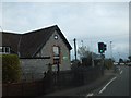
1
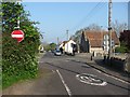
Crossroads and Methodist chapel, East Brent
Old Bristol Road meets the A370 Bridgwater Road.
Image: © Richard Webb
Taken: 19 Apr 2011
0.02 miles
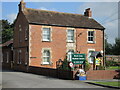
2
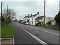
Cottages on Brent Road
A date stone over a cottage called The Stores is recorded as 1797.
Image: © Anthony Vosper
Taken: 7 Apr 2018
0.03 miles
3
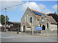
East Brent Methodist Church
This little church was founded in 1871 at a cost to the worshippers of £450. Its history provides an interesting insight into the progress in a small village:
1920 - a pulpit was purchased
1925 - concrete laid around the chapel
1930 - electricity installed at a cost of £9-16 shillings
1945 - water supply to vestry was laid on with one indoor tap and an Elsan toilet in the outside shed
1946 - gas heating installed
1964 - tender accepted for construction of a schoolroom £7,700 plus £150 for flooring with full facilities.
Image: © Neil Owen
Taken: 15 Sep 2021
0.03 miles
5
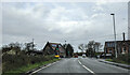
On the A370 heading north at East Brent, approaching the junction with the B3140
Image: © Rob Purvis
Taken: 8 Jan 2022
0.04 miles
6
Anvil House
Nowadays it is the Brent Area Medical Centre, but the datestone of 1889 and the name suggests it was a smithy in a previous time.
Image: © Neil Owen
Taken: 15 Sep 2021
0.05 miles
8
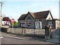
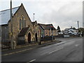
East Brent Village Hall
Former school.
Image: © Richard Webb
Taken: 19 Apr 2011
0.05 miles
9
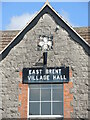
A shielding sign
The weathered sign blocks some of the window, but manages to avoid the flagpole holder.
Image: © Neil Owen
Taken: 15 Sep 2021
0.05 miles
10
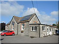
East Brent village hall
Originally the building was a school, but is now a community facility.
Image: © Neil Owen
Taken: 15 Sep 2021
0.05 miles