IMAGES TAKEN NEAR TO
Walrow Terrace, HIGHBRIDGE, TA9 4AA
Introduction
This page details the photographs taken nearby to Walrow Terrace, TA9 4AA by members of the Geograph project.
The Geograph project started in 2005 with the aim of publishing, organising and preserving representative images for every square kilometre of Great Britain, Ireland and the Isle of Man.

There are currently over 7.5m images from over14,400 individuals and you can help contribute to the project by visiting https://www.geograph.org.uk
Image Map
Images are licensed for reuse under creativecommons.org/licenses/by-sa/2.0
Notes
- Clicking on the map will re-center to the selected point.
- The higher the marker number, the further away the image location is from the centre of the postcode.
Image Listing (96 Images Found)
Images are licensed for reuse under creativecommons.org/licenses/by-sa/2.0
Image
Details
Distance
1

Walrow Terrace, Highbridge
On the north side of the B3139 Walrow.
Image: © Jaggery
Taken: 10 Dec 2014
0.01 miles
2

Walrow houses, Highbridge
On the north side of the B3139 Walrow.
Image: © Jaggery
Taken: 10 Dec 2014
0.08 miles
3
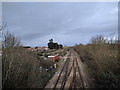
Railway line heading to Bristol, at Highbridge
Image: © Rob Purvis
Taken: 18 Jan 2019
0.09 miles
5
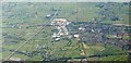
Highbridge from the air
From an aircraft above Brent Knoll. The M5 (left) and the main railway line converge. Junction 22 on the motorway is at bottom left. The white of the business units on the Isleport Business Park contrasts with the rest of the town across the railway.
Image: © Derek Harper
Taken: 8 Sep 2016
0.09 miles
6
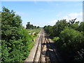
Railway towards Weston-super-Mare
From the bridge on Walrow (B3139), Highbridge.
Image: © JThomas
Taken: 12 Jul 2019
0.09 miles
7
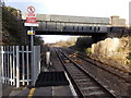
Railway towards Weston-super-Mare from Highbridge
Viewed from the northern edge of Highbridge & Burnham railway station looking under the B3139 road bridge. This is the Taunton to Bristol main line. Next station ahead is Weston-super-Mare, about 14km (c9 miles) away.
Image: © Jaggery
Taken: 10 Dec 2014
0.09 miles
8
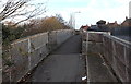
Footbridge alongside a narrow road bridge, Highbridge
Attached to the north side of the road bridge http://www.geograph.org.uk/photo/4450355 over railway lines near Highbridge & Burnham station
Image: © Jaggery
Taken: 10 Dec 2014
0.10 miles
9
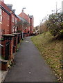
Somerset Way path towards Highbridge & Burnham railway station
The path between Somerset Way houses and the B3139 Walrow leads to the eastern entrance to the station.
Image: © Jaggery
Taken: 10 Dec 2014
0.10 miles
10

Somerset Way, Highbridge
Modern housing on the south side of the B3139 Walrow.
Image: © Jaggery
Taken: 10 Dec 2014
0.10 miles