IMAGES TAKEN NEAR TO
Church Road, HIGHBRIDGE, TA9 3RL
Introduction
This page details the photographs taken nearby to Church Road, TA9 3RL by members of the Geograph project.
The Geograph project started in 2005 with the aim of publishing, organising and preserving representative images for every square kilometre of Great Britain, Ireland and the Isle of Man.

There are currently over 7.5m images from over14,400 individuals and you can help contribute to the project by visiting https://www.geograph.org.uk
Image Map
Images are licensed for reuse under creativecommons.org/licenses/by-sa/2.0
Notes
- Clicking on the map will re-center to the selected point.
- The higher the marker number, the further away the image location is from the centre of the postcode.
Image Listing (52 Images Found)
Images are licensed for reuse under creativecommons.org/licenses/by-sa/2.0
Image
Details
Distance
1
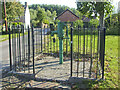
Huntspill pump
The water had supplied the village for many generations. Now it has its own fence to highlight its value.
Image: © Neil Owen
Taken: 14 Sep 2020
0.06 miles
2
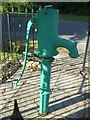
Huntspill's water supply in times past
The pump, a product of Llewellins & James of Bristol, on the south perimeter of the village is now well protected.
Image: © Neil Owen
Taken: 14 Sep 2020
0.06 miles
3
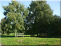
Huntspill's green lungs
The south of the village has some open stretches of green and plenty of trees to enjoy.
Image: © Neil Owen
Taken: 14 Sep 2020
0.07 miles
4
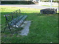
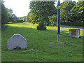
A seat for watching the traffic go by
The seat faces the very busy A38 Pawlett Road at the junction with Huntspill. The jubilee stone refers to West Huntspill which is just down that same road.
Image: © Neil Owen
Taken: 14 Sep 2020
0.07 miles
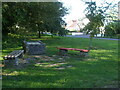
5
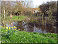
Blocks by the Pawlett Road
The entrance to the southern end of Huntspill has a little ribbon of greenery and some odd concrete blocks
Image: © Neil Owen
Taken: 14 Sep 2020
0.07 miles
8
A spot of rest at the end of Sloway Lane
The village of Huntspill reaches close to the river and at the southern road junction is a place to rest and read about its history. The latter board was a Millennium project, created in February, 2000.
Image: © Neil Owen
Taken: 14 Sep 2020
0.09 miles
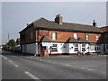
9
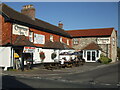
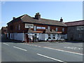
The Crossways Inn, Huntspill
The inn dates back to the seventeenth century and was a prime venue for coaching. These days it appears to be a serial pub award winner.
Image: © Neil Owen
Taken: 14 Sep 2020
0.09 miles