IMAGES TAKEN NEAR TO
Burnham Road, HIGHBRIDGE, TA9 3JG
Introduction
This page details the photographs taken nearby to Burnham Road, TA9 3JG by members of the Geograph project.
The Geograph project started in 2005 with the aim of publishing, organising and preserving representative images for every square kilometre of Great Britain, Ireland and the Isle of Man.

There are currently over 7.5m images from over14,400 individuals and you can help contribute to the project by visiting https://www.geograph.org.uk
Image Map
Images are licensed for reuse under creativecommons.org/licenses/by-sa/2.0
Notes
- Clicking on the map will re-center to the selected point.
- The higher the marker number, the further away the image location is from the centre of the postcode.
Image Listing (42 Images Found)
Images are licensed for reuse under creativecommons.org/licenses/by-sa/2.0
Image
Details
Distance
1
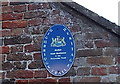
Oval plaque on Huish, Highbridge
A Highbridge Heritage Trail blue plaque is on a wall of this http://www.geograph.org.uk/photo/4303528 building.
Image: © Jaggery
Taken: 10 Dec 2014
0.02 miles
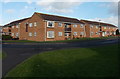
2
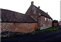
Grade II listed Huish, Highbridge
Mid 18th century house, perhaps the site of the manor house of the small local manor of Huish.
Grade II listed in 1985. Out of shot, an oval plaque http://www.geograph.org.uk/photo/4303537 states that Huish was mentioned in the Domesday Book (1086).
Image: © Jaggery
Taken: 10 Dec 2014
0.03 miles
3
Paddock Drive, Highbridge
Viewed from Old Burnham Road.
Image: © Jaggery
Taken: 10 Dec 2014
0.05 miles
4
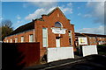
Gospel Centre, Highbridge
Gospel Centre (Gospel Tabernacle Evangelical Church)
is at the edge of Daunton Close, http://www.geograph.org.uk/photo/4274375 near Old Burnham Road.
Image: © Jaggery
Taken: 10 Dec 2014
0.06 miles
5
Daunton Close, Highbridge
Houses and flats opposite the Gospel Centre. http://www.geograph.org.uk/photo/4274367
Image: © Jaggery
Taken: 10 Dec 2014
0.08 miles
6
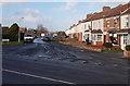
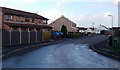
Junction of Old Burnham Road and Burnham Road in Highbridge
Old Burnham Road heads away from the B3139 Burnham Road.
Image: © Jaggery
Taken: 10 Dec 2014
0.08 miles
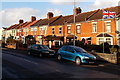
7
Old Burnham Road houses in Highbridge
Viewed from the corner of Paddock Drive looking along Old Burnham Road towards Burnham Road.
Image: © Jaggery
Taken: 10 Dec 2014
0.09 miles
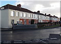
8
Flying the flag in Highbridge
At the eastern end of a row of houses on the north side of Burnham Road.
Image: © Jaggery
Taken: 10 Dec 2014
0.14 miles
9
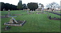
Highbridge Cemetery
Viewed from near the Burnham Road entrance. http://www.geograph.org.uk/photo/4303605
Image: © Jaggery
Taken: 10 Dec 2014
0.15 miles
10
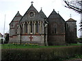
HIGHBRIDGE, Somerset
The church of St John the Evangelist, now shorn of its tower and spire.
Image: © ChurchCrawler
Taken: 4 Mar 2004
0.16 miles