IMAGES TAKEN NEAR TO
Tyler Way, HIGHBRIDGE, TA9 3FZ
Introduction
This page details the photographs taken nearby to Tyler Way, TA9 3FZ by members of the Geograph project.
The Geograph project started in 2005 with the aim of publishing, organising and preserving representative images for every square kilometre of Great Britain, Ireland and the Isle of Man.

There are currently over 7.5m images from over14,400 individuals and you can help contribute to the project by visiting https://www.geograph.org.uk
Image Map
Images are licensed for reuse under creativecommons.org/licenses/by-sa/2.0
Notes
- Clicking on the map will re-center to the selected point.
- The higher the marker number, the further away the image location is from the centre of the postcode.
Image Listing (166 Images Found)
Images are licensed for reuse under creativecommons.org/licenses/by-sa/2.0
Image
Details
Distance
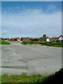
1
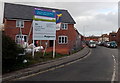
Tyler Way house construction, Highbridge
Viewed in December 2014.
Image: © Jaggery
Taken: 10 Dec 2014
0.01 miles
2
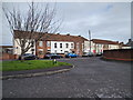
Tyler Way joining Newtown Road in Highbridge
Image: © Rob Purvis
Taken: 18 Jan 2019
0.03 miles
3
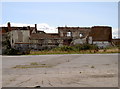
The cattle have long gone
The old cattle market in Highbridge closed many years ago. The area, at the rear of the former Highbridge Hotel, was purchased and filled in (as it is part of the River Brue). The river bed was covered with wattle hurdles, then large stones from a quarry, followed by smaller waste and then more hurdles. Once the new land had settled it took all the weight of many lorry-loads of animals. See Image for the façade of the hotel.
Image: © Neil Owen
Taken: 13 Aug 2013
0.03 miles
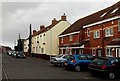
4
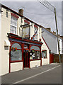
The Globe Inn
An old two storey type of pub in Newtown Road.
Image: © Neil Owen
Taken: 13 Aug 2013
0.03 miles
5
Highbridge Wharf
This is the view north-west from the site of the original ‘high bridge’ to what was once Highbridge Wharf. When a new cut was made in 1801-09, as part of the River Brue Drainage Scheme, the old course of the Brue, including the wharf, was bypassed. Nonetheless, it managed to remain in commercial use, though at the last only in a small way, until the 1950s. Then it was surfaced, and used for what became the largest cattle market in the south-west; but that too closed in 2007.
Image: © Kerryn
Taken: 22 May 2009
0.04 miles
6
Parked cars in Newtown Road, Highbridge
Viewed from the corner of the A38 Church Street.
Image: © Jaggery
Taken: 10 Dec 2014
0.04 miles
7
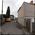
Kings Street towards CJK vehicle repairs in Highbridge
A CJK van is parked at the edge of The Yard, the premises of CJK Vehicle Repairs Ltd.
A notice on the fence on the right shows that parking is reserved for residents only. Unauthorised vehicles will be clamped.
Image: © Jaggery
Taken: 10 Dec 2014
0.05 miles
8
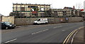
Scaffolding on the shell of the former Highbridge Hotel in Highbridge
Viewed across the A38 Huntspill Road in December 2014. House construction work is in progress near the shell. See http://www.geograph.org.uk/photo/3680324 for an earlier view and some details.
Image: © Jaggery
Taken: 10 Dec 2014
0.06 miles
9
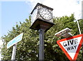
A new fellow amongst the metalworks
Highbridge had a clock on the roundabout for many years but it was considered a tad unworthy. So, after a donation of some £17,000 was received from local fundraising, the local council approved a new clock to replace the concrete version. Indeed, that was known as 'the three-faced liar' as its faces often told different times.
The new clock is four-faced (even though one will only be visible to passing pedestrians) and was completed in time for the Diamond Jubilee. All efforts are now being focussed on replacing the uninviting brick walls in front of it. See Image] for a memorial stone nearby.
Image: © Neil Owen
Taken: 13 Aug 2013
0.06 miles
10
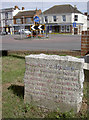
Jubilee Stone
The small patch of grass beside the main roundabout in Highbridge is properly called the Jubilee Gardens. This stone marks the Queen's Silver one in 1977. As a monument to the Diamond celebrations a new clock was installed - see Image] or Image] for some cheery flowers.
Image: © Neil Owen
Taken: 13 Aug 2013
0.06 miles