IMAGES TAKEN NEAR TO
Kiln Drive, HIGHBRIDGE, TA9 3EL
Introduction
This page details the photographs taken nearby to Kiln Drive, TA9 3EL by members of the Geograph project.
The Geograph project started in 2005 with the aim of publishing, organising and preserving representative images for every square kilometre of Great Britain, Ireland and the Isle of Man.

There are currently over 7.5m images from over14,400 individuals and you can help contribute to the project by visiting https://www.geograph.org.uk
Image Map
Images are licensed for reuse under creativecommons.org/licenses/by-sa/2.0
Notes
- Clicking on the map will re-center to the selected point.
- The higher the marker number, the further away the image location is from the centre of the postcode.
Image Listing (139 Images Found)
Images are licensed for reuse under creativecommons.org/licenses/by-sa/2.0
Image
Details
Distance
1
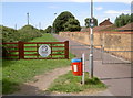
Apex Park entrance
This way to the old brickworks lakes. It's also a cycle path and part of National Route 33.
Image: © Neil Owen
Taken: 13 Aug 2013
0.02 miles
2
The end of the route, the beginning of the road
The cycle path through Apex Park stops here, although Route 33 carries on into town.
Image: © Neil Owen
Taken: 13 Aug 2013
0.03 miles
3
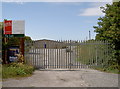
Waiting for a new occupant
A small industrial estate alongside the seafront, silent for now.
Image: © Neil Owen
Taken: 13 Aug 2013
0.04 miles
4
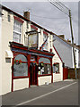
The Globe Inn
An old two storey type of pub in Newtown Road.
Image: © Neil Owen
Taken: 13 Aug 2013
0.11 miles
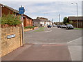
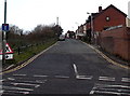
5
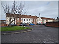
Tyler Way joining Newtown Road in Highbridge
Image: © Rob Purvis
Taken: 18 Jan 2019
0.13 miles
6
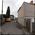
Kings Street towards CJK vehicle repairs in Highbridge
A CJK van is parked at the edge of The Yard, the premises of CJK Vehicle Repairs Ltd.
A notice on the fence on the right shows that parking is reserved for residents only. Unauthorised vehicles will be clamped.
Image: © Jaggery
Taken: 10 Dec 2014
0.14 miles
7
Eastern end of Clyce Road, Highbridge
Viewed from the A38 Huntspill Road end. Clyce Road is a 450 metre long dead-end street. The houses are all on one side, opposite the River Brue. New Clyce Bridge is at the far end of the road. Clyce is a local word for a sluice or lock.
Image: © Jaggery
Taken: 10 Dec 2014
0.14 miles
8
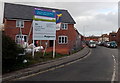
Tyler Way house construction, Highbridge
Viewed in December 2014.
Image: © Jaggery
Taken: 10 Dec 2014
0.14 miles
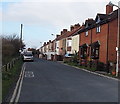
9

Highbridge : Clyce Road
Looking along Clyce Road in Highbridge.
Image: © Lewis Clarke
Taken: 24 Feb 2018
0.15 miles
10
Clyce Road, Highbridge
Viewed across Huntspill Road. Clyce Road is a 450 metre long dead-end street along a bank
of the River Brue. New Clyce Bridge is at the far end. Clyce is a local word for a sluice or lock.
Image: © Jaggery
Taken: 10 Dec 2014
0.15 miles