IMAGES TAKEN NEAR TO
Station Road, BRIDGWATER, TA7 9NW
Introduction
This page details the photographs taken nearby to Station Road, TA7 9NW by members of the Geograph project.
The Geograph project started in 2005 with the aim of publishing, organising and preserving representative images for every square kilometre of Great Britain, Ireland and the Isle of Man.

There are currently over 7.5m images from over14,400 individuals and you can help contribute to the project by visiting https://www.geograph.org.uk
Image Map
Images are licensed for reuse under creativecommons.org/licenses/by-sa/2.0
Notes
- Clicking on the map will re-center to the selected point.
- The higher the marker number, the further away the image location is from the centre of the postcode.
Image Listing (14 Images Found)
Images are licensed for reuse under creativecommons.org/licenses/by-sa/2.0
Image
Details
Distance
2
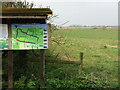
Shapwick Moor - Information Board
Overlooking flat grassy land administered by The Hawk and Owl Trust.
Image: © Colin Smith
Taken: 30 Mar 2022
0.06 miles
4
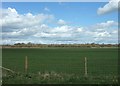
Shapwick Moor
Nature reserve beside the Avalon Marshes. It is administered by The Hawk and Owl Trust.
Image: © Colin Smith
Taken: 30 Mar 2022
0.08 miles
5
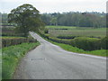
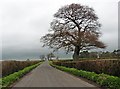
Farmland north of Moorgate Farm
Looking towards Canada Farm from the Hawk and Owl Trust's car park.
Image: © Simon Huguet
Taken: 6 Apr 2009
0.13 miles
8
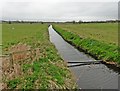
Shapwick Moor Rhyne
A late afternoon view towards the lowering sun of the rhyne shown in Image, from Station Road.
Image: © Derek Harper
Taken: 6 May 2019
0.17 miles
9
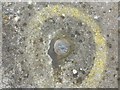
Benchmark on bridge, Station Road, Shapwick
Internal Drainage Boards benchmark on west parapet of bridge over Shapwick Moor Rhyne in the Somerset Levels. See https://eabm.derektp.co.uk/detail?eabm=34
An Ordnance Survey rivet benchmark was installed on a bridge here in 1961 but was lost when the bridge was rebuilt.
Image: © Becky Williamson
Taken: 9 Aug 2015
0.18 miles
10
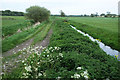
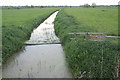
Shapwick Moor Rhyne
The scene on the other side of Station Road from Image]; see also Image This is part of Shapwick Heath National Nature Reserve.
Image: © Derek Harper
Taken: 6 May 2019
0.18 miles