IMAGES TAKEN NEAR TO
Manor Road, BRIDGWATER, TA7 9HB
Introduction
This page details the photographs taken nearby to Manor Road, TA7 9HB by members of the Geograph project.
The Geograph project started in 2005 with the aim of publishing, organising and preserving representative images for every square kilometre of Great Britain, Ireland and the Isle of Man.

There are currently over 7.5m images from over14,400 individuals and you can help contribute to the project by visiting https://www.geograph.org.uk
Image Map
Images are licensed for reuse under creativecommons.org/licenses/by-sa/2.0
Notes
- Clicking on the map will re-center to the selected point.
- The higher the marker number, the further away the image location is from the centre of the postcode.
Image Listing (31 Images Found)
Images are licensed for reuse under creativecommons.org/licenses/by-sa/2.0
Image
Details
Distance
1
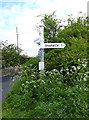
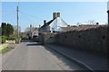
Old Direction Sign - Signpost by Broadway, Edington
Pyramid finial - 3 arms; Somerset SCC pyramid by the UC road, in parish of Edington (Sedgemoor District), Manor Road junction with Broadway, by Edington chapel.
Surveyed
Milestone Society National ID: SO_ST3839A
Image: © Alan Rosevear
Taken: 27 Apr 2014
0.06 miles
3
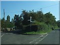
Differing approaches to salvation
Edington chapel now has the modern surgery for company. The banner saying 'Try Praying' is perhaps a little inadvertent next to the clinic.
Church-goers in Catcott were holding services under tents but a Gospel Hall was built in 1904. It served until the surgery and new village hall were built here in 1979. As worshippers dwindled, the hall changed to Edington Chapel to embrace the variety of creeds now involved. The chapel was renovated in the 2000s to offer modern facilities for the village.
Image: © Neil Owen
Taken: 14 Oct 2021
0.07 miles
4
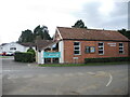
The Village Hall Edington
Edington and neighbouring Catcott used to have a wooden hall, run by the Women's Institute and situated on upper Holywell Road. It was becoming cramped and so plans were drawn up to build a new hall and surgery here in 1979. It has had extensions since opening and now offers its services to all the Polden villages.
Image: © Neil Owen
Taken: 14 Oct 2021
0.08 miles
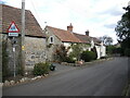
5
Listed buildings in Catcott
The Manor House, originally C17, is described at https://www.historicengland.org.uk/listing/the-list/list-entry/1173072 . Beyond is The Old House, which may be a little older, described at https://www.historicengland.org.uk/listing/the-list/list-entry/1060164 as "Tudoresque".
Image: © Derek Harper
Taken: 13 Mar 2016
0.09 miles
6
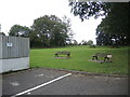
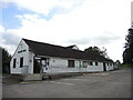
Picnic area behind the hall
The Village Hall Edington has open green space for enjoyment and relaxation.
Image: © Neil Owen
Taken: 14 Oct 2021
0.10 miles
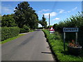
8
Along Manor Road, Catcott
A benchmark can be found on the wall of the barn opposite the junction with Old School Lane. See Image
Image: © Neil Owen
Taken: 14 Oct 2021
0.13 miles
9
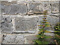
Benchmark on Manor Road, Catcott
A more recent addition to the list on an outbuilding in the village. See https://www.bench-marks.org.uk/bm164645 for the entry in the Benchmark Database and Image] for a wider view.
Image: © Neil Owen
Taken: 14 Oct 2021
0.13 miles
10
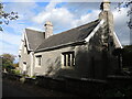
Catcott school
The original building of 1842 is still in use, along with more modern additions.
Image: © Neil Owen
Taken: 14 Oct 2021
0.14 miles