IMAGES TAKEN NEAR TO
Stagman Lane, BRIDGWATER, TA7 9BJ
Introduction
This page details the photographs taken nearby to Stagman Lane, TA7 9BJ by members of the Geograph project.
The Geograph project started in 2005 with the aim of publishing, organising and preserving representative images for every square kilometre of Great Britain, Ireland and the Isle of Man.

There are currently over 7.5m images from over14,400 individuals and you can help contribute to the project by visiting https://www.geograph.org.uk
Image Map
Images are licensed for reuse under creativecommons.org/licenses/by-sa/2.0
Notes
- Clicking on the map will re-center to the selected point.
- The higher the marker number, the further away the image location is from the centre of the postcode.
Image Listing (5 Images Found)
Images are licensed for reuse under creativecommons.org/licenses/by-sa/2.0
Image
Details
Distance


3

Footpath to Millslade Farm
Obstructed by cropping of maize.
Image: © Patrick Mackie
Taken: 25 Aug 2006
0.17 miles
4
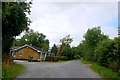
House on the Whitley Rd
This small house is next to an incongruous entrance. It does however lead to a very large poultry farm hidden behind the trees belonging to D&M Poultry. It occupies an area that on the old maps is shown as Whitley woods, but there are very few trees there now.
Image: © Nigel Mykura
Taken: 5 Aug 2015
0.19 miles
5
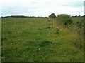
Fields near Ashcott
A footpath runs along the fence in this view.
Image: © Patrick Mackie
Taken: 25 Aug 2006
0.20 miles