IMAGES TAKEN NEAR TO
Stawell, BRIDGWATER, TA7 9AA
Introduction
This page details the photographs taken nearby to TA7 9AA by members of the Geograph project.
The Geograph project started in 2005 with the aim of publishing, organising and preserving representative images for every square kilometre of Great Britain, Ireland and the Isle of Man.

There are currently over 7.5m images from over14,400 individuals and you can help contribute to the project by visiting https://www.geograph.org.uk
Image Map
Images are licensed for reuse under creativecommons.org/licenses/by-sa/2.0
Notes
- Clicking on the map will re-center to the selected point.
- The higher the marker number, the further away the image location is from the centre of the postcode.
Image Listing (7 Images Found)
Images are licensed for reuse under creativecommons.org/licenses/by-sa/2.0
Image
Details
Distance
3
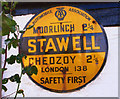
Old circular AA Sign on Stawell Road in Stawell
Old AA Sign on the north facing wall of the Old Post Office, a house on Stawell Road in Stawell, 5 miles east of Bridgwater. Stawell parish.
This is the circular, village name on black band, no Motor Union symbol or name type, dating to 1923 and showing distances Moorlinch 2¼ Chedzoy 2¼ London 138.
There were five series of AA signs, mostly dating from 1923 and made by Francis & Co / Franco in Deptford, London. The village name and distance to London were usually displayed.
See also https://3.bp.blogspot.com/-q8fQXpnLIFE/WooB1mKDiYI/AAAAAAAAWZ4/zB6_RyB7tYIT7gbllifaW-BvFXlVvlE5wCKgBGAs/s1600/DSCN6615.JPG.
Milestone Society National ID: SO-STAW
Image: © Milestone Society
Taken: Unknown
0.14 miles
5
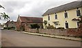
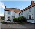
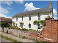
Manor, Stawell
With adjacent barn; both are listed. The Manor Farmhouse is dated 1735 http://list.historicengland.org.uk/resultsingle.aspx?uid=1174254&searchtype=mapsearch , and its forecourt wall is included; the barn is probably contemporaneous http://list.historicengland.org.uk/resultsingle.aspx?uid=1174263&searchtype=mapsearch .
Image: © Derek Harper
Taken: 25 Apr 2015
0.22 miles
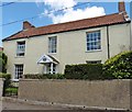
7
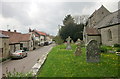
Street and church, Stawell
From the raised churchyard, with Image on the right http://list.historicengland.org.uk/resultsingle.aspx?uid=1174228&searchtype=mapsearch .
Image: © Derek Harper
Taken: 25 Apr 2015
0.24 miles