IMAGES TAKEN NEAR TO
Woolavington Road, BRIDGWATER, TA7 8BE
Introduction
This page details the photographs taken nearby to Woolavington Road, TA7 8BE by members of the Geograph project.
The Geograph project started in 2005 with the aim of publishing, organising and preserving representative images for every square kilometre of Great Britain, Ireland and the Isle of Man.

There are currently over 7.5m images from over14,400 individuals and you can help contribute to the project by visiting https://www.geograph.org.uk
Image Map
Images are licensed for reuse under creativecommons.org/licenses/by-sa/2.0
Notes
- Clicking on the map will re-center to the selected point.
- The higher the marker number, the further away the image location is from the centre of the postcode.
Image Listing (50 Images Found)
Images are licensed for reuse under creativecommons.org/licenses/by-sa/2.0
Image
Details
Distance
1
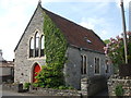
The old chapel
Puriton's old Congregational Chapel, now a private residence.
Image: © Neil Owen
Taken: 30 Apr 2019
0.01 miles
2
The corners clipped
A pair of pre-Worboys road signs in Puriton have been subjected to some deterioration.
Image: © Neil Owen
Taken: 30 Apr 2019
0.03 miles
3
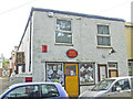
Puriton Post Office
The current venue is a modern one; previously, the office was a few yards down Middle Street nearer the crossroads.
Image: © Neil Owen
Taken: 30 Apr 2019
0.05 miles
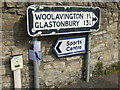
4
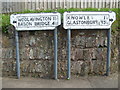
Road Junction Puriton
This junction with its old road signs in the centre of the village marks where the road south to the A39 leaves the road from Puriton to Woolavington.
Image: © Nigel Mykura
Taken: 17 Nov 2010
0.05 miles
5
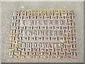
Local iron
Locally-made ironwork is not so common these days.
Edmund Millard started with a smithy in Bridgwater and grew it into the Bath Bridge Engineering Works by the 1890s. In 1924, the firm became part of Bale, Millard and Sons, so this cover may be a lot older than it might seem.
Image: © Neil Owen
Taken: 30 Apr 2019
0.05 miles
6
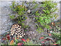
Life and death in Puriton
Some Spring greenery, right beside some recycling.
Image: © Neil Owen
Taken: 30 Apr 2019
0.06 miles
7
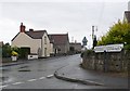
All sorts of signs
Some Pre-Worboys, some modern, some utility, some home spun.
Image: © Neil Owen
Taken: 30 Apr 2019
0.07 miles
8
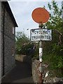
No bicycles off Middle Street
The lane is not for wheeled transport. The sign is an old-fashioned type with a solid red circle and a notice below - long since discontinued. Interestingly, the other end of the lane also has a similar sign.
Image: © Neil Owen
Taken: 30 Apr 2019
0.07 miles
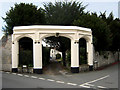
10
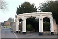
Gateway to Puriton Manor
There are already two photos of this fine gateway on the site, Image and Image I apologise for adding another, but 1) I've included part of the village lane named Rye on the left, leading up Rye Green by the church, and 2) here is a link to the listed building description https://www.historicengland.org.uk/listing/the-list/list-entry/1296223 , which begins "Probably C18, though may incorporate some C15/C16 material. Painted freestone. Neo-Perpendicular." Rather dismissively, the description states that "Puriton Manor {visible in both the other images} is not of special interest".
Image: © Derek Harper
Taken: 13 Mar 2016
0.07 miles