IMAGES TAKEN NEAR TO
Grove Hill, BRIDGWATER, TA7 0JG
Introduction
This page details the photographs taken nearby to Grove Hill, TA7 0JG by members of the Geograph project.
The Geograph project started in 2005 with the aim of publishing, organising and preserving representative images for every square kilometre of Great Britain, Ireland and the Isle of Man.

There are currently over 7.5m images from over14,400 individuals and you can help contribute to the project by visiting https://www.geograph.org.uk
Image Map
Images are licensed for reuse under creativecommons.org/licenses/by-sa/2.0
Notes
- Clicking on the map will re-center to the selected point.
- The higher the marker number, the further away the image location is from the centre of the postcode.
Image Listing (11 Images Found)
Images are licensed for reuse under creativecommons.org/licenses/by-sa/2.0
Image
Details
Distance
1
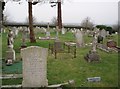
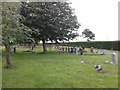
Othery Cemetery
Clinging to the edge of the higher land above the Levels, the cemetery looks peaceful and pretty. However the busy A361 runs along the left hand side and behind the photographer is a mixture of modern pylons and ugly industrial development.
Image: © Barbara Cook
Taken: 31 Jan 2006
0.09 miles
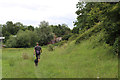
2
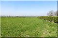
Field near Othery
Drier ground above the moors and with a hedge rather than a rhyne.
Image: © Richard Webb
Taken: 6 Apr 2015
0.12 miles
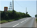
4
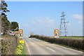
A361, Othery
Othery was once an island in marshy ground before the moors were drained.
Image: © Richard Webb
Taken: 6 Apr 2015
0.15 miles
5
A blind summit in mid Somerset
The land around Othery is pretty flat by most standards. However, on the Somerset Levels the difference between sea level and a noticeable hill is slight. Here Othery stands on an old island that reaches to 22m on the A361 - hence you cannot see over it!
Image: © Neil Owen
Taken: 23 Jun 2020
0.20 miles
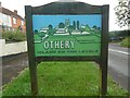
6
The island on the levels
Othery stands on what is a prominent parcel of land in the middle of Somerset and this lends itself to the claim. The millennium sign is certainly three-dimensional.
Image: © Neil Owen
Taken: 23 Jun 2020
0.22 miles
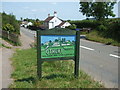
7
Village Name Board, Othery
This name board erected in the year 2000, is on the A391 Main Road west of Othery, its postcode being TA7 0QE. It shows an outline of the village with St Michael's Church on the horizon. Othery is known as the Island on the Levels and further information on the village is on the Wikipedia website at https://en.wikipedia.org/wiki/Othery.
Image: © David Hillas
Taken: 8 Aug 2023
0.22 miles
9
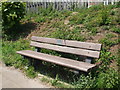
A seat on the entry to Othery
This bench seat has been provided by the local Women's Institute with help from the village Millennium fund in 2000.
Image: © Neil Owen
Taken: 23 Jun 2020
0.23 miles
