IMAGES TAKEN NEAR TO
Cheer Lane, BRIDGWATER, TA7 0EY
Introduction
This page details the photographs taken nearby to Cheer Lane, TA7 0EY by members of the Geograph project.
The Geograph project started in 2005 with the aim of publishing, organising and preserving representative images for every square kilometre of Great Britain, Ireland and the Isle of Man.

There are currently over 7.5m images from over14,400 individuals and you can help contribute to the project by visiting https://www.geograph.org.uk
Image Map
Images are licensed for reuse under creativecommons.org/licenses/by-sa/2.0
Notes
- Clicking on the map will re-center to the selected point.
- The higher the marker number, the further away the image location is from the centre of the postcode.
Image Listing (116 Images Found)
Images are licensed for reuse under creativecommons.org/licenses/by-sa/2.0
Image
Details
Distance
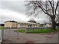
3
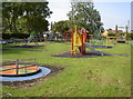
Westonzoyland play park
One for the youngsters, right by the village hall and recreation ground.
Image: © Neil Owen
Taken: 10 Sep 2015
0.06 miles
4

A rebel brass
The Battle of Sedgemoor took place very close to the village of Westonzoyland in 1685. Those supporters of James Scott, the rebel Duke of Monmouth, were a numerical match for the royalists, but were comprehensively defeated. The battle has a trail laid out from the church to the battlefield, with markers such as this one.
Image: © Neil Owen
Taken: 10 Sep 2015
0.08 miles
5
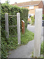
The trail turns right
The path that leads from St Mary's church up to King's Drive, is part of the official trail of the Battle of Sedgemoor. The brown post directs historians north to the battle field.
Image: © Neil Owen
Taken: 10 Sep 2015
0.09 miles
6

Westonzoyland village hall
This community facility was, as its styling suggests, formerly a military building. The nearby R.A.F. Westonzoyland station was an occasional airfield from its founding in 1926, but the advent of WWII brought a vast increase in men and machinery. This building dates from 1942 and was used as a cinema and gymnasium. Later, after the end of hostilities, it became the village school but is now the hall, residing by the recreation ground.
Image: © Neil Owen
Taken: 10 Sep 2015
0.09 miles
7
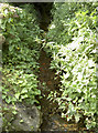
Draining the excess
Westonzoyland can be found in the Somerset Levels and as such is never very far above the water table. Drainage ditches and rhynes criss-cross the village, like this one which appears under a path.
Image: © Neil Owen
Taken: 10 Sep 2015
0.10 miles
9
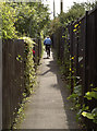
Barely enough elbow room
A cyclist takes the narrow path that runs between Kings Drive and the church.
Image: © Neil Owen
Taken: 10 Sep 2015
0.12 miles
10
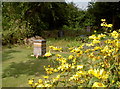
Food on their doorstep
One of three beehives on a narrow plot of land that is given over to allotments. Most of the produce is for the table although some flowers are present.
Image: © Neil Owen
Taken: 10 Sep 2015
0.12 miles