IMAGES TAKEN NEAR TO
Silverdale Close, BRIDGWATER, TA6 7PT
Introduction
This page details the photographs taken nearby to Silverdale Close, TA6 7PT by members of the Geograph project.
The Geograph project started in 2005 with the aim of publishing, organising and preserving representative images for every square kilometre of Great Britain, Ireland and the Isle of Man.

There are currently over 7.5m images from over14,400 individuals and you can help contribute to the project by visiting https://www.geograph.org.uk
Image Map (Loading...)


Getting Data...Please wait
Leaflet Map data © OpenStreetMap
Images are licensed for reuse under creativecommons.org/licenses/by-sa/2.0
Notes
- Clicking on the map will re-center to the selected point.
- The higher the marker number, the further away the image location is from the centre of the postcode.
Image Listing (7 Images Found)
Images are licensed for reuse under creativecommons.org/licenses/by-sa/2.0
Image
Details
Distance


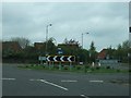
4
Houses beside the A39 south of Wembdon
A cycle track emerges on the left, having been routed away from a busy roundabout
Image: © David Smith
Taken: 14 Apr 2011
0.22 miles
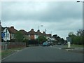
5
Quantock Road (A39), Bridgwater
A cycle path runs out of the town beside the road and this is the point where cyclists have to join the main road
Image: © David Smith
Taken: 11 May 2018
0.23 miles
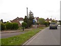
6
Northern Distributor Road, Bridgwater
Otherwise known as Homberg Way. The chimneys of the Gerber soft drinks factory in the background
Image: © Ken Grainger
Taken: 12 Oct 2008
0.23 miles
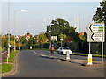
7

Field by Quantock Road
The building in the field looks as if it is a collapsed barn, and appears to have been there some time.
Image: © David Smith
Taken: 14 Apr 2011
0.24 miles