IMAGES TAKEN NEAR TO
Wembdon Road, BRIDGWATER, TA6 7DP
Introduction
This page details the photographs taken nearby to Wembdon Road, TA6 7DP by members of the Geograph project.
The Geograph project started in 2005 with the aim of publishing, organising and preserving representative images for every square kilometre of Great Britain, Ireland and the Isle of Man.

There are currently over 7.5m images from over14,400 individuals and you can help contribute to the project by visiting https://www.geograph.org.uk
Image Map
Images are licensed for reuse under creativecommons.org/licenses/by-sa/2.0
Notes
- Clicking on the map will re-center to the selected point.
- The higher the marker number, the further away the image location is from the centre of the postcode.
Image Listing (40 Images Found)
Images are licensed for reuse under creativecommons.org/licenses/by-sa/2.0
Image
Details
Distance
2
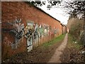
Brick wall by the Gerber factory
The footpath (number BW 38/11) runs between the Gerber Foods soft drinks factory (shown in Image) and Image, and connects Wembdon Road to Halesleigh Road.
Image: © Derek Harper
Taken: 26 Jan 2010
0.03 miles
3
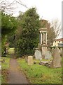
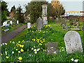
Bridgwater Cemetery
Seen from Wembdon Road. Warning signs deter anyone from entering. A shame, as it looks a restful and attractive green space. The cemetery spreads across four grid squares.
Image: © Derek Harper
Taken: 26 Jan 2010
0.07 miles
4
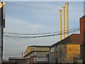
Three chimneys, Bridgwater
The Gerber Foods soft drinks factory.
Image: © Ken Grainger
Taken: 16 Mar 2009
0.09 miles
5
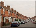
Halesleigh Road, Bridgwater
On the left is a terrace of 25 properties. Two terraces succeed it; they are in Image Seen from the end of the path shown in Image
Image: © Derek Harper
Taken: 26 Jan 2010
0.10 miles
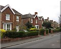
6
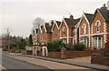
Houses on Wembdon Road, Bridgwater
This row of gabled houses, set back a little from the curve of the old turnpike road to Ashcott, has nice loopy bargeboard decorations.
Image: © Derek Harper
Taken: 26 Jan 2010
0.10 miles
7
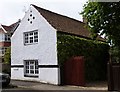
Old Toll House, Bridgwater
Toll House in the parish of Bridgwater No. 119, Wembdon Road (cut off section), TA6 7PJ.
Grade II listed.
List Entry Number: 1297137 https://historicengland.org.uk/listing/the-list/list-entry/1297137
Surveyed
Milestone Society National ID: SO.WEM01
Image: © Alan Rosevear
Taken: 24 Jun 2013
0.17 miles
8
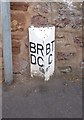
Old Boundary Marker on Wembdon Road
Parish Boundary Marker by the UC road, on the boundary of Bridgwater and Wembdon parishes (Sedgemoor District), on the northeast side of Wembdon Road, now a cul-de-sac on the southeast side of the A39 Homberg Way. On the boundary of Wembdon parish, Bridgwater Rural District Council and Bridgwater parish, Bridgwater Town (Borough) Council. Opposite Boundary Marker: SO_BGWE01pb Image
Somerset HER.
HER number: 26720 https://www.heritagegateway.org.uk/Gateway/Results_Single.aspx?uid=26720&resourceID=100
Surveyed
Milestone Society National ID: SO_BGWE02pb
Image: © A Rosevear
Taken: 24 Jun 2013
0.19 miles
9
Northfield
Residential street in Bridgwater.
Image: © Richard Webb
Taken: 31 Mar 2012
0.20 miles
10
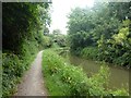
Towpath and canal passing through Westover, Bridgwater
Image: © David Smith
Taken: 5 Aug 2020
0.20 miles