IMAGES TAKEN NEAR TO
Wembdon Road, BRIDGWATER, TA6 7DN
Introduction
This page details the photographs taken nearby to Wembdon Road, TA6 7DN by members of the Geograph project.
The Geograph project started in 2005 with the aim of publishing, organising and preserving representative images for every square kilometre of Great Britain, Ireland and the Isle of Man.

There are currently over 7.5m images from over14,400 individuals and you can help contribute to the project by visiting https://www.geograph.org.uk
Image Map
Images are licensed for reuse under creativecommons.org/licenses/by-sa/2.0
Notes
- Clicking on the map will re-center to the selected point.
- The higher the marker number, the further away the image location is from the centre of the postcode.
Image Listing (126 Images Found)
Images are licensed for reuse under creativecommons.org/licenses/by-sa/2.0
Image
Details
Distance
1
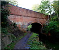
South side of canal bridge 2, Bridgwater
The bridge carries Wembdon Road over the Bridgwater & Taunton canal.
Image: © Jaggery
Taken: 4 Oct 2012
0.02 miles
2
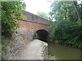
Wembdon Road bridge over canal, Bridgwater
Image: © David Smith
Taken: 5 Aug 2020
0.02 miles
3

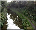
Bridge No 2, Bridgwater and Taunton Canal
Image: © Roger Cornfoot
Taken: 12 Nov 2016
0.02 miles
4
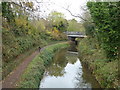
Canal between bridge 1 and bridge 2, Bridgwater
The Bridgwater & Taunton canal viewed from Victoria Road
on canal bridge number 1 http://www.geograph.org.uk/photo/4482563 towards bridge number 2 (Wembdon Road).
Image: © Jaggery
Taken: 4 Oct 2012
0.02 miles
5
Bridgwater & Taunton Canal
Looking towards the marina with Victoria Road bridge in the distance.
Image: © Chris Allen
Taken: 14 Nov 2016
0.03 miles
6
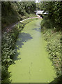
A green carpet
The canal as seen from Wembdon Road bridge - covered in bright green vegetation.
Image: © Neil Owen
Taken: 5 Sep 2013
0.04 miles
7
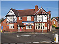
The Maltshovel, Bridgwater
Wembdon Road
Image: © Ken Grainger
Taken: 12 Oct 2008
0.04 miles
8
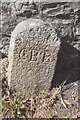
Old Boundary Marker on the A39 Wembdon Road
County Bridge Marker against the low stone wall of the car park of the Malt Shovel PH on the north side of the A39 Wembdon Road. Bridgwater parish. Inscribed C B B. 40 metres northeast of the road bridge over the Bridgwater and Taunton Canal.
Milestone Society National ID: SO_BRIDG03br
Image: © R Raynsford
Taken: Unknown
0.05 miles
9
The Maltshovel, Bridgwater
The pub is at 2 Wembdon Road, opposite the mini-roundabout where the A39 North Street becomes the A39 Wembdon Road. The Bridgwater and Taunton Canal is 50 metres to the west.
Most references show The Malt Shovel, but the name sign clearly shows The Maltshovel.
Image: © Jaggery
Taken: 4 Oct 2012
0.06 miles
10
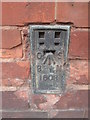
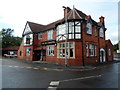
Ordnance Survey Flush Bracket (1608)
This OS Flush Bracket can be found on the front of the Malt Shovel Public House. It marks a point 12.128m above mean sea level.
Image: © Adrian Dust
Taken: 19 Oct 2015
0.06 miles