IMAGES TAKEN NEAR TO
Fallow View Road, BRIDGWATER, TA6 7DB
Introduction
This page details the photographs taken nearby to Fallow View Road, TA6 7DB by members of the Geograph project.
The Geograph project started in 2005 with the aim of publishing, organising and preserving representative images for every square kilometre of Great Britain, Ireland and the Isle of Man.

There are currently over 7.5m images from over14,400 individuals and you can help contribute to the project by visiting https://www.geograph.org.uk
Image Map (28 Images)


Getting Data...Please wait
Leaflet Map data © OpenStreetMap
Images are licensed for reuse under creativecommons.org/licenses/by-sa/2.0
Notes
- Clicking on the map will re-center to the selected point.
- The higher the marker number, the further away the image location is from the centre of the postcode.
Image Listing (28 Images Found)
Images are licensed for reuse under creativecommons.org/licenses/by-sa/2.0
Image
Details
Distance
1
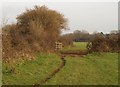
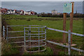
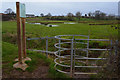
Gateway, The Meads
Footpath BW 38/18 runs along the northern side of The Meads, but swings right here towards the Hamp Brook side of the meadows.
Image: © Derek Harper
Taken: 26 Jan 2010
0.05 miles
2
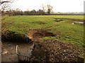
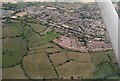
The Meads
The Meads is a miniature area of the Somerset Levels where the Durleigh Brook (foreground) joins the Hamp Brook. The irregular ground may be where former drainage channels existed.
Image: © Derek Harper
Taken: 26 Jan 2010
0.10 miles
3
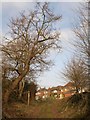
Haygrove Lane
Footpath BW 38/18 climbs the lane to meet Haygrove Road and the start of the housing above the Durleigh Brook valley.
Image: © Derek Harper
Taken: 26 Jan 2010
0.11 miles
4
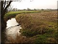
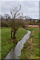
Durleigh Brook
Seen from footpath BW 38/18 at the foot of Haygrove Lane; looking upstream.
Image: © Derek Harper
Taken: 26 Jan 2010
0.12 miles
5
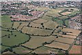
Cropmarks on the Meads between Durleigh Brook and Hamp Brook: aerial 2019
Image: © Chris
Taken: 8 Aug 2019
0.15 miles
6
Cropmarks on the Meads between Durleigh Brook and Hamp Brook: aerial 2019 (2)
Image: © Chris
Taken: 8 Aug 2019
0.15 miles
7
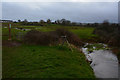
Bridgwater : Small Stream
A small stream heading through the grassy field.
Image: © Lewis Clarke
Taken: 20 Feb 2016
0.18 miles
8
Bridgwater : The Meads Eco-Park
A footpath heads into the eco-park and onwards towards Bridgwater.
Image: © Lewis Clarke
Taken: 20 Feb 2016
0.19 miles
9
Bridgwater : Grassy Field
A wet grassy field with a right of way heading through it.
Image: © Lewis Clarke
Taken: 20 Feb 2016
0.19 miles
10
Bridgwater : The Meads Eco-Park
A footpath heads through the eco-park in Bridgwater.
Image: © Lewis Clarke
Taken: 20 Feb 2016
0.19 miles