IMAGES TAKEN NEAR TO
Nicholls Close, BRIDGWATER, TA6 7AP
Introduction
This page details the photographs taken nearby to Nicholls Close, TA6 7AP by members of the Geograph project.
The Geograph project started in 2005 with the aim of publishing, organising and preserving representative images for every square kilometre of Great Britain, Ireland and the Isle of Man.

There are currently over 7.5m images from over14,400 individuals and you can help contribute to the project by visiting https://www.geograph.org.uk
Image Map
Images are licensed for reuse under creativecommons.org/licenses/by-sa/2.0
Notes
- Clicking on the map will re-center to the selected point.
- The higher the marker number, the further away the image location is from the centre of the postcode.
Image Listing (47 Images Found)
Images are licensed for reuse under creativecommons.org/licenses/by-sa/2.0
Image
Details
Distance
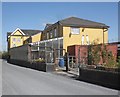
2
Northfield
Residential street in Bridgwater.
Image: © Richard Webb
Taken: 31 Mar 2012
0.11 miles
3
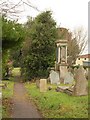
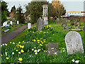
Bridgwater Cemetery
Seen from Wembdon Road. Warning signs deter anyone from entering. A shame, as it looks a restful and attractive green space. The cemetery spreads across four grid squares.
Image: © Derek Harper
Taken: 26 Jan 2010
0.11 miles
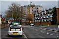
4
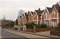
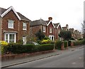
Houses on Wembdon Road, Bridgwater
This row of gabled houses, set back a little from the curve of the old turnpike road to Ashcott, has nice loopy bargeboard decorations.
Image: © Derek Harper
Taken: 26 Jan 2010
0.14 miles
5
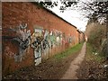
Brick wall by the Gerber factory
The footpath (number BW 38/11) runs between the Gerber Foods soft drinks factory (shown in Image) and Image, and connects Wembdon Road to Halesleigh Road.
Image: © Derek Harper
Taken: 26 Jan 2010
0.14 miles
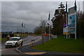
6

Bridgwater : Durleigh Road
A road heading into Bridgwater and past The Horse & Jockey.
Image: © Lewis Clarke
Taken: 20 Feb 2016
0.15 miles
8
Bridgwater : Durleigh Road
Heading along Durleigh Road as it heads into the centre of Bridgwater.
Image: © Lewis Clarke
Taken: 20 Feb 2016
0.18 miles
9
Bridgwater : Haygrove Park Road
A road so new it doesn't appear on the OS Map. This photo is taken from Durleigh Road.
Image: © Lewis Clarke
Taken: 20 Feb 2016
0.19 miles
10
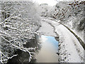
Bridgwater and Taunton Canal in winter
Image: © Ken Grainger
Taken: 18 Dec 2010
0.19 miles