IMAGES TAKEN NEAR TO
Taunton Road, BRIDGWATER, TA6 6AD
Introduction
This page details the photographs taken nearby to Taunton Road, TA6 6AD by members of the Geograph project.
The Geograph project started in 2005 with the aim of publishing, organising and preserving representative images for every square kilometre of Great Britain, Ireland and the Isle of Man.

There are currently over 7.5m images from over14,400 individuals and you can help contribute to the project by visiting https://www.geograph.org.uk
Image Map (Loading...)


Getting Data...Please wait
Leaflet Map data © OpenStreetMap
Images are licensed for reuse under creativecommons.org/licenses/by-sa/2.0
Notes
- Clicking on the map will re-center to the selected point.
- The higher the marker number, the further away the image location is from the centre of the postcode.
Image Listing (99 Images Found)
Images are licensed for reuse under creativecommons.org/licenses/by-sa/2.0
Image
Details
Distance
1
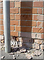
Losing the footings
A benchmark in Fernleigh Avenue, looking as though it may not be as accurate as it used to be. See Image] for a wider view and http://www.bench-marks.org.uk/bm52032 for the entry in the Benchmark Database.
Image: © Neil Owen
Taken: 5 Sep 2013
0.03 miles
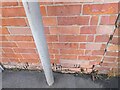
2

Fernleigh Avenue
At the bottom of the wall beside the cul-de-sac sign is a benchmark. See Image] for a look at the mark and the crumbling brickwork.
Image: © Neil Owen
Taken: 5 Sep 2013
0.03 miles
3
Ordnance Survey Cut Mark
This OS cut mark can be found on No62 Taunton Road. It marks a point 9.101m above mean sea level.
Image: © Adrian Dust
Taken: 16 Jan 2023
0.03 miles
4
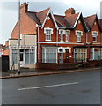
Jeralds barbershop in Bridgwater
The nameboard on 74A Taunton Road shows Jeralds Gents Hair.
Image: © Jaggery
Taken: 4 Oct 2012
0.03 miles
5
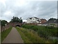
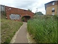
Canal towpath approaching A38 bridge, Bridgwater
The bridge carries Taunton Road (A38)
Image: © David Smith
Taken: 5 Aug 2020
0.03 miles
6
Old Taunton Road bridge over canal, Bridgwater
Image: © David Smith
Taken: 5 Aug 2020
0.03 miles
7
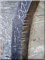
The action of many a tow rope
Some of the iron corner pieces on the canal bridge under the Old Taunton Road, showing the effect of all those taut barge ropes.
Image: © Neil Owen
Taken: 5 Sep 2013
0.03 miles
8
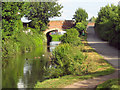
Bridgwater and Taunton Canal
Bridge over the A38 Taunton Road, Bridgwater
Image: © Ken Grainger
Taken: 16 Sep 2007
0.03 miles
9
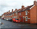
Old Taunton Road houses, Bridgwater
A 65 metre long row of houses on the east side of Old Taunton Road, viewed from the corner of Southgate Avenue.
Image: © Jaggery
Taken: 4 Oct 2012
0.04 miles
10
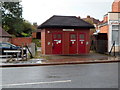
Taunton Road public toilets, Bridgwater
Viewed across the A38 Taunton Road from near the corner of Southgate Avenue.
Jeralds barber shop http://www.geograph.org.uk/photo/3952701 is on the right.
Image: © Jaggery
Taken: 4 Oct 2012
0.04 miles