IMAGES TAKEN NEAR TO
Stafford Road, BRIDGWATER, TA6 5PH
Introduction
This page details the photographs taken nearby to Stafford Road, TA6 5PH by members of the Geograph project.
The Geograph project started in 2005 with the aim of publishing, organising and preserving representative images for every square kilometre of Great Britain, Ireland and the Isle of Man.

There are currently over 7.5m images from over14,400 individuals and you can help contribute to the project by visiting https://www.geograph.org.uk
Image Map (Loading...)


Getting Data...Please wait
Leaflet Map data © OpenStreetMap
Images are licensed for reuse under creativecommons.org/licenses/by-sa/2.0
Notes
- Clicking on the map will re-center to the selected point.
- The higher the marker number, the further away the image location is from the centre of the postcode.
Image Listing (9 Images Found)
Images are licensed for reuse under creativecommons.org/licenses/by-sa/2.0
Image
Details
Distance
1
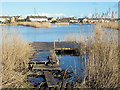
Dunwear Ponds, Bridgwater
Old gravel quarries, now used as fishing lakes.
Image: © Ken Grainger
Taken: 18 Nov 2007
0.07 miles
6
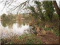
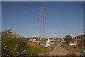
One of Dunwear Ponds
The easternmost of four ponds on the site of a former clay pit. Dunwear Ponds form a County Wildlife Site and are used for angling - platforms can be seen on the far side.
Image: © Derek Harper
Taken: 26 Jan 2010
0.23 miles
8
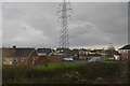
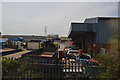
Sedgemoor Road, Bridgwater
Viewed across Westonzoyland Road.
Image: © Jaggery
Taken: 4 Oct 2012
0.24 miles
9
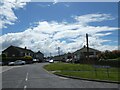
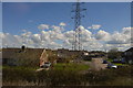
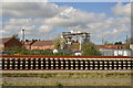
Sedgemoor Road, Bridgwater
This road has a slight bend as it joins the A372. This appears to correspond to a track marked in a mid-20th century OS map
Image: © David Smith
Taken: 3 Jul 2022
0.24 miles