IMAGES TAKEN NEAR TO
Loxleigh Avenue, BRIDGWATER, TA6 5BH
Introduction
This page details the photographs taken nearby to Loxleigh Avenue, TA6 5BH by members of the Geograph project.
The Geograph project started in 2005 with the aim of publishing, organising and preserving representative images for every square kilometre of Great Britain, Ireland and the Isle of Man.

There are currently over 7.5m images from over14,400 individuals and you can help contribute to the project by visiting https://www.geograph.org.uk
Image Map
Images are licensed for reuse under creativecommons.org/licenses/by-sa/2.0
Notes
- Clicking on the map will re-center to the selected point.
- The higher the marker number, the further away the image location is from the centre of the postcode.
Image Listing (107 Images Found)
Images are licensed for reuse under creativecommons.org/licenses/by-sa/2.0
Image
Details
Distance
1
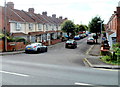
Loxleigh Avenue, Bridgwater
Viewed from Westonzoyland Road.
Image: © Jaggery
Taken: 4 Oct 2012
0.01 miles
2
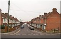
Loxleigh Avenue, Bridgwater
Contrasting terraces face each other in this street immediately east of the railway line, and seen here from Westonzoyland Road.
Image: © Derek Harper
Taken: 26 Jan 2010
0.03 miles
4
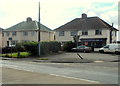
Dolphin Fish Bar, Bridgwater
Fish and chip shop on the corner of Westonzoyland Road and Penzoy Avenue.
Image: © Jaggery
Taken: 4 Oct 2012
0.07 miles
5
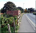
Pillbox on the east side of Westonzoyland Road railway bridge, Bridgwater
Located on the east side of Westonzoyland Road railway bridge. There is another pillbox on the west side of the bridge. http://www.geograph.org.uk/photo/3165505
The pillboxes were part of The Taunton Stop Line, a World War II defensive line in SW England. It was designed to stop an enemy's advance from the west and in particular a rapid advance supported by armoured fighting vehicles (up to the size of a German medium tank) which may have broken through the forward defences.
After the war, farmers on whose land the pillboxes had been built, were paid £5 for each one they demolished. However, most of the very solid structures have survived, though many are in varying stages of decay after seven decades.
Image: © Jaggery
Taken: 4 Oct 2012
0.07 miles
6
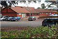
Redgate Medical Centre, Bridgwater
On the north side of Westonzoyland Road, between Redgate Street and Clarks Road.
There is a Lloyds Pharmacy on the left.
Image: © Jaggery
Taken: 4 Oct 2012
0.07 miles
7
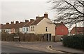
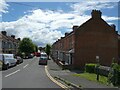
Redgate Street, Bridgwater
The street, whose junction with Westonzoyland Road is in the foreground, bends sharply to the left, which explains why these are the rears of houses on its south side.
Image: © Derek Harper
Taken: 26 Jan 2010
0.07 miles
8
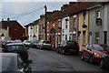
Bridgwater : Redgate Street
Lots of satellite dishes seen here on the houses in Redgate Street.
Image: © Lewis Clarke
Taken: 20 Feb 2016
0.08 miles
9
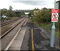
Westonzoyland Road bridge, Bridgwater
Viewed from the southern edge of Bridgwater railway station.
The bridge carries Westonzoyland Road (the A372)
Image: © Jaggery
Taken: 4 Oct 2012
0.09 miles
10
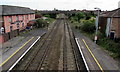
Railway between two footbridges, Bridgwater
Viewed from the footbridge http://www.geograph.org.uk/photo/5387385 over the southern end of Bridgwater railway station looking towards the footbridge attached to the north side of the A372 Westonzoyland Road bridge. The Commercial Inn http://www.geograph.org.uk/photo/5387371 is on the left.
Image: © Jaggery
Taken: 3 Apr 2017
0.09 miles