IMAGES TAKEN NEAR TO
Eastover, BRIDGWATER, TA6 5AG
Introduction
This page details the photographs taken nearby to Eastover, TA6 5AG by members of the Geograph project.
The Geograph project started in 2005 with the aim of publishing, organising and preserving representative images for every square kilometre of Great Britain, Ireland and the Isle of Man.

There are currently over 7.5m images from over14,400 individuals and you can help contribute to the project by visiting https://www.geograph.org.uk
Image Map
Images are licensed for reuse under creativecommons.org/licenses/by-sa/2.0
Notes
- Clicking on the map will re-center to the selected point.
- The higher the marker number, the further away the image location is from the centre of the postcode.
Image Listing (525 Images Found)
Images are licensed for reuse under creativecommons.org/licenses/by-sa/2.0
Image
Details
Distance
1
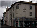
Corner of Eastover and East Quay
Looking down towards the Taxi rank
Image: © Elaine Smith
Taken: 25 Jul 2008
0.02 miles
3
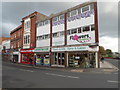
Eastover shops near the corner of Salmon Parade, Bridgwater
The corner shop is Flowers International. On its left are Eastover Food & Wine and
the red frontage of a British Heart Foundation charity shop.
Salmon Parade on the east bank of the River Parrett is at the right edge of the view.
Image: © Jaggery
Taken: 4 Oct 2012
0.02 miles
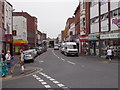
4
Eastover, Bridgwater
A selection of shops and restaurants east of the river.
Image: © Richard Webb
Taken: 31 Mar 2012
0.02 miles
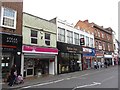
5

Proper Job in former Woolworths, Bridgwater
Proper Job DiY store opened here at 18-20 Eastover, Bridgwater in 2010. The shop had been empty since its previous occupier, Woolworths, ceased trading here at the end of 2008, and nationwide by early January 2009.
Image: © Jaggery
Taken: 4 Oct 2012
0.03 miles
6
East Quay, Bridgwater
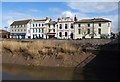
Seen from West Quay. Each of the buildings is listed, though Pevsner feels that only no 4, the white Georgian house with blue window surrounds, is worthy of note, and it is earlier (C18) than the others http://webapp1.somerset.gov.uk/her/details.asp?prn=14854 . Number 2, however, is remarkable for its parapet with volutes http://webapp1.somerset.gov.uk/her/details.asp?prn=14852 . The others are described at (left to right) http://webapp1.somerset.gov.uk/her/details.asp?prn=14853 , http://webapp1.somerset.gov.uk/her/details.asp?prn=14853 and http://webapp1.somerset.gov.uk/her/details.asp?prn=14851
Image: © Derek Harper
Taken: 15 Feb 2010
0.03 miles
7
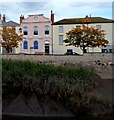
East Quay viewed from West Quay, Bridgwater
Looking across the River Parrett towards the office of Colin Fear Insurance Services Ltd in East Quay.
Image: © Jaggery
Taken: 4 Oct 2012
0.03 miles
9
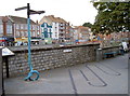
A knotty problem?
East Quay in Bridgwater now has some reminders of its working past, with this rope-like signpost and 'uncoiled' paving.
Image: © Neil Owen
Taken: 30 Aug 2012
0.03 miles
10
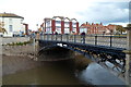
Town Bridge, Bridgwater
Viewed across the River Parrett from West Quay. The bridge was erected in 1883, replacing its predecessor of 1795. Before that year, the exact nature of the river crossing here is unclear, though it must date back to ancient times. The Domesday Book (1086) records Bridgwater as Walter's Bridge, a reference to this location, which was the only road crossing of the river in the town until the 1960s.
By that decade the volume of traffic was causing long delays at what had become a serious bottleneck.
Image: © Jaggery
Taken: 4 Oct 2012
0.03 miles