IMAGES TAKEN NEAR TO
Bailey Street, BRIDGWATER, TA6 4PF
Introduction
This page details the photographs taken nearby to Bailey Street, TA6 4PF by members of the Geograph project.
The Geograph project started in 2005 with the aim of publishing, organising and preserving representative images for every square kilometre of Great Britain, Ireland and the Isle of Man.

There are currently over 7.5m images from over14,400 individuals and you can help contribute to the project by visiting https://www.geograph.org.uk
Image Map
Images are licensed for reuse under creativecommons.org/licenses/by-sa/2.0
Notes
- Clicking on the map will re-center to the selected point.
- The higher the marker number, the further away the image location is from the centre of the postcode.
Image Listing (127 Images Found)
Images are licensed for reuse under creativecommons.org/licenses/by-sa/2.0
Image
Details
Distance
1
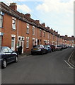
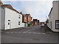
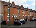
Houses on the east side of Bailey Street, Bridgwater
Bailey Street is between Bath Road and Rosebery Avenue.
Image: © Jaggery
Taken: 3 Apr 2017
0.04 miles
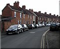
2
Rosebery Avenue, Bridgwater
A terraced street in this Somerset town.
Image: © Jonathan Billinger
Taken: 7 Oct 2008
0.06 miles
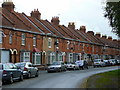
3
Rosebery Avenue, Bridgwater
Viewed from the A39 Bath Road end.
Rosebery Avenue extends for about 200 metres to the corner of Bailey Street.
All the houses in Rosebery Avenue are on one side on the road, opposite trees and bushes.
Image: © Jaggery
Taken: 3 Apr 2017
0.07 miles
4
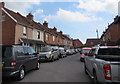
Vehicles in Branksome Avenue, Bridgwater
From this viewpoint there is nowhere left to park in Branksome Avenue at 2:18 on a Monday afternoon in April 2017. Branksome Avenue is a cul-de-sac extending for 60 metres from the A39 Bath Road.
Image: © Jaggery
Taken: 3 Apr 2017
0.07 miles
5
Cornborough Place Bridgwater
Dead end street on the east side of Wellington Road.
Image: © Jaggery
Taken: 3 Apr 2017
0.07 miles
6
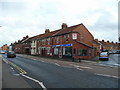
Corner of Bath Road and Rosebery Avenue
The Bath Road, A39, is the road to the left, heading north-east out of Bridgwater.
The shop on the corner sells remote-control models.
Image: © Jonathan Billinger
Taken: 7 Oct 2008
0.08 miles
7
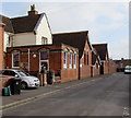
Eastover Community Primary School Bridgwater
The southern edge of the school viewed across Cornborough Place.
Image: © Jaggery
Taken: 3 Apr 2017
0.08 miles
8
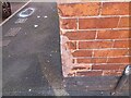
Ordnance Survey Cut Mark
This OS cut mark can be found on No14 Cornborough Place. It marks a point 7.394m above mean sea level.
Image: © Adrian Dust
Taken: 16 Jan 2023
0.09 miles
9
Incised Bailey Street name sign, Bridgwater
At the Bath Road end of the street, BAILEY STREET is incised on a first floor tablet partly hidden by a drainpipe.
Image: © Jaggery
Taken: 3 Apr 2017
0.09 miles
10
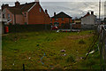
Bridgwater : Grassy Area
A grassy and rather untidy looking area on Bath Road.
Image: © Lewis Clarke
Taken: 20 Feb 2016
0.09 miles