IMAGES TAKEN NEAR TO
Castlefields, BRIDGWATER, TA6 4DF
Introduction
This page details the photographs taken nearby to Castlefields, TA6 4DF by members of the Geograph project.
The Geograph project started in 2005 with the aim of publishing, organising and preserving representative images for every square kilometre of Great Britain, Ireland and the Isle of Man.

There are currently over 7.5m images from over14,400 individuals and you can help contribute to the project by visiting https://www.geograph.org.uk
Image Map
Images are licensed for reuse under creativecommons.org/licenses/by-sa/2.0
Notes
- Clicking on the map will re-center to the selected point.
- The higher the marker number, the further away the image location is from the centre of the postcode.
Image Listing (193 Images Found)
Images are licensed for reuse under creativecommons.org/licenses/by-sa/2.0
Image
Details
Distance
1
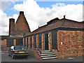
Bridgwater brick and tile factory
Now a museum
Image: © Ken Grainger
Taken: 13 Sep 2008
0.04 miles
2
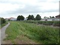
Footpath and reeds by River Parrett, Bridgwater
Image: © David Smith
Taken: 5 Aug 2020
0.05 miles
3
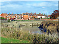
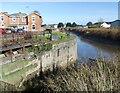
The River Parrett at Bridgwater
Flowing north out of the town towards the Bristol Channel, past flood defence walls.
Image: © Ken Grainger
Taken: 19 Nov 2007
0.05 miles
5
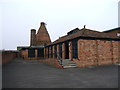
Somerset Brick and Tile Museum
This free museum is located in the preserved buildings that were part of a former brick and tile works.
Image: © Ruth Riddle
Taken: 13 Oct 2011
0.06 miles
6
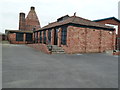
Somerset Brick and Tile Museum
Incorporating a bottle oven-like brick kiln, This is the only standing structure of this type in Bridgwater although there is the base of a glass cone nearby. The Museum is open two days per week and not currently at weekends.
Image: © Chris Allen
Taken: 23 Feb 2013
0.06 miles
7
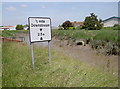
Mind your head!
A height warning for marine traffic on the River Parrett, not unlike road signs.
Image: © Neil Owen
Taken: 17 Jun 2014
0.08 miles
8
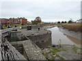
River Parrett, Bridgwater
Seen from alongside the disused and sealed lock that provided access from the River Parrett to Bridgwater Docks. The Bridgwater & Taunton Canal connects to the far end of the docks.
Image: © Chris Allen
Taken: 14 Nov 2016
0.09 miles
9
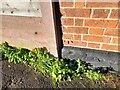
Ordnance Survey Cut Mark
This OS cut mark can be found on No1 Dock Cottages. It marks a point 8.483m above mean sea level.
Image: © Adrian Dust
Taken: 16 Jan 2023
0.09 miles
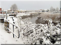
10
Former canal basin lock entrance on River Parrett
Image: © Roger Cornfoot
Taken: 12 Nov 2016
0.09 miles