IMAGES TAKEN NEAR TO
Oak Apple Drive, BRIDGWATER, TA6 3UN
Introduction
This page details the photographs taken nearby to Oak Apple Drive, TA6 3UN by members of the Geograph project.
The Geograph project started in 2005 with the aim of publishing, organising and preserving representative images for every square kilometre of Great Britain, Ireland and the Isle of Man.

There are currently over 7.5m images from over14,400 individuals and you can help contribute to the project by visiting https://www.geograph.org.uk
Image Map
Images are licensed for reuse under creativecommons.org/licenses/by-sa/2.0
Notes
- Clicking on the map will re-center to the selected point.
- The higher the marker number, the further away the image location is from the centre of the postcode.
Image Listing (11 Images Found)
Images are licensed for reuse under creativecommons.org/licenses/by-sa/2.0
Image
Details
Distance
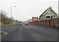
1
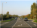
Northern Distributor Road, Bridgwater
Otherwise known as Homberg Way.
Image: © Ken Grainger
Taken: 12 Oct 2008
0.13 miles
2
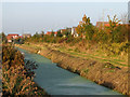
Nature reserve alongside Homberg Way
Separating Bridgwater and Wembdon Village
Image: © Ken Grainger
Taken: 12 Oct 2008
0.13 miles
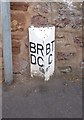
4
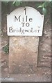
Old Milestone, B3339, Wembdon Hill, Wembdon
The milestone set into the stone wall of No. 12 on the north side of the road. Parish of Wembdon (Sedgemoor District). Metal plate attached to stone post, Bridgewater iron plate design, erected by the Bridgwater turnpike trust in the 18th century.
Inscription reads:-
1 / Mile / To / Bridgwater
Grade II Listed. List Entry Number: 1237590 https://historicengland.org.uk/listing/the-list/list-entry/1237590
Milestone Society National ID: SO_BGMH01
Image: © JR Dowding
Taken: 14 Jul 2002
0.19 miles
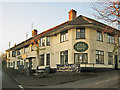
5

Wembdon : Wembdon Cricket Club
Looking towards the cricket club in Wembdon.
Image: © Lewis Clarke
Taken: 22 May 2018
0.19 miles
6
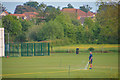
Wembdon : Wembdon Cricket Club
Looking towards a man on the pitch at the cricket club.
Image: © Lewis Clarke
Taken: 22 May 2018
0.20 miles
8
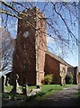
St. Georges, Wembdon
Tucked away on a quiet road on the very edge of Wembdon, the parish church was looking splendid in the spring sunshine and the bells were pealing as well!
Image: © Barbara Cook
Taken: 3 Apr 2006
0.23 miles
9
Old Boundary Marker on Wembdon Road
Parish Boundary Marker by the UC road, on the boundary of Bridgwater and Wembdon parishes (Sedgemoor District), on the northeast side of Wembdon Road, now a cul-de-sac on the southeast side of the A39 Homberg Way. On the boundary of Wembdon parish, Bridgwater Rural District Council and Bridgwater parish, Bridgwater Town (Borough) Council. Opposite Boundary Marker: SO_BGWE01pb Image
Somerset HER.
HER number: 26720 https://www.heritagegateway.org.uk/Gateway/Results_Single.aspx?uid=26720&resourceID=100
Surveyed
Milestone Society National ID: SO_BGWE02pb
Image: © A Rosevear
Taken: 24 Jun 2013
0.24 miles
10

Old Boundary Marker on Wembdon Road
Parish Boundary Marker by the UC road, on the boundary of Bridgwater and Wembdon parishes (Sedgemoor District), on the southwest side of Wembdon Road, now a cul-de-sac on the southeast side of the A39 Homberg Way. On the boundary of Bridgwater parish, Bridgwater Town (Borough) Council and Wembdon parish, Bridgwater Rural District Council. Opposite Boundary Marker: SO_BGWE02pb Image
Somerset HER.
HER number: 26720 https://www.heritagegateway.org.uk/Gateway/Results_Single.aspx?uid=26720&resourceID=100
Surveyed
Milestone Society National ID: SO_BGWE01pb
Image: © A Rosevear
Taken: 24 Jun 2013
0.24 miles