IMAGES TAKEN NEAR TO
Kendale Road, BRIDGWATER, TA6 3QG
Introduction
This page details the photographs taken nearby to Kendale Road, TA6 3QG by members of the Geograph project.
The Geograph project started in 2005 with the aim of publishing, organising and preserving representative images for every square kilometre of Great Britain, Ireland and the Isle of Man.

There are currently over 7.5m images from over14,400 individuals and you can help contribute to the project by visiting https://www.geograph.org.uk
Image Map (Loading...)


Getting Data...Please wait
Leaflet Map data © OpenStreetMap
Images are licensed for reuse under creativecommons.org/licenses/by-sa/2.0
Notes
- Clicking on the map will re-center to the selected point.
- The higher the marker number, the further away the image location is from the centre of the postcode.
Image Listing (154 Images Found)
Images are licensed for reuse under creativecommons.org/licenses/by-sa/2.0
Image
Details
Distance
1
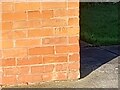
Ordnance Survey Cut Mark
This OS cut mark can be found on No132 Kendale Road. It marks a point 10.526m above mean sea level.
Image: © Adrian Dust
Taken: 16 Jan 2023
0.05 miles
2
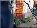
Ordnance Survey Cut Mark
This OS cut mark can be found on No185 Kendale Road. It marks a point 9.982m above mean sea level.
Image: © Adrian Dust
Taken: 16 Jan 2023
0.05 miles
3
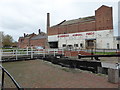
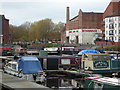
Bridgwater - animal feed mill and canal lock
This is where the Bridgwater & Taunton Canal enters Bridgwater docks that are now shown on the map as a marina. Beyond is the still working Bowerings Animal Feeds mill with an elegant but disused chimney. This lock appears to be permanently open as the docks are no longer connected to the tidal River Parrett.
Image: © Chris Allen
Taken: 14 Nov 2016
0.07 miles
5
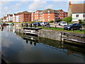
Bridgwater Marina
The former docks of 1841 that are now a marina at the end of the Taunton & Bridgwater Canal. They are now isolated from the River Parrett. Bowerings Animal Feed Mill is seen in the background.
Image: © Chris Allen
Taken: 14 Nov 2016
0.07 miles
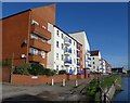
6
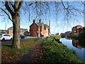
Flats alongside Bridgwater Marina
Poskitt House, Grenville Court, Sharman Court and Maddocks Court viewed from Northgate.
The edge of Russell Place http://www.geograph.org.uk/photo/5355350 is on the right.
Image: © Jaggery
Taken: 3 Apr 2017
0.07 miles
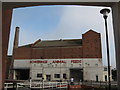
8
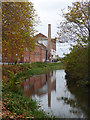
Bridgwater & Taunton Canal
Approaching the former docks that are now a marina and with the active animal feed mills on the left of the cut. The chimney, though, is no longer in use. Nice reflection.
Image: © Chris Allen
Taken: 14 Nov 2016
0.07 miles
9
Apartment blocks beside Bridgwater canal basin
Image: © Roger Cornfoot
Taken: 12 Nov 2016
0.07 miles
10
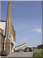
The docks still in work
The chimney might well not be fired up these days but at least the rest of the old docks warehouses continue to operate.
Image: © Neil Owen
Taken: 17 Jun 2014
0.07 miles