IMAGES TAKEN NEAR TO
Kendale Road, BRIDGWATER, TA6 3QB
Introduction
This page details the photographs taken nearby to Kendale Road, TA6 3QB by members of the Geograph project.
The Geograph project started in 2005 with the aim of publishing, organising and preserving representative images for every square kilometre of Great Britain, Ireland and the Isle of Man.

There are currently over 7.5m images from over14,400 individuals and you can help contribute to the project by visiting https://www.geograph.org.uk
Image Map
Images are licensed for reuse under creativecommons.org/licenses/by-sa/2.0
Notes
- Clicking on the map will re-center to the selected point.
- The higher the marker number, the further away the image location is from the centre of the postcode.
Image Listing (33 Images Found)
Images are licensed for reuse under creativecommons.org/licenses/by-sa/2.0
Image
Details
Distance
1
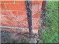
Ordnance Survey Cut Mark
This OS cut mark can be found on No30 Kendale Road. It marks a point 11.534m above mean sea level.
Image: © Adrian Dust
Taken: 16 Jan 2023
0.04 miles
2
Ordnance Survey Cut Mark
This OS cut mark can be found on No42 Victoria Road. It marks a point 12.552m above mean sea level.
Image: © Adrian Dust
Taken: 16 Jan 2023
0.10 miles
3
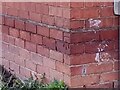
Ordnance Survey Cut Mark
This OS cut mark can be found on No82 Kendale Road. It marks a point 9.952m above mean sea level.
Image: © Adrian Dust
Taken: 16 Jan 2023
0.14 miles
4
Nature reserve alongside Homberg Way
Separating Bridgwater and Wembdon Village
Image: © Ken Grainger
Taken: 12 Oct 2008
0.15 miles
5
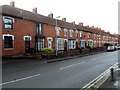
Victoria Road houses, Bridgwater
Viewed from the corner of Lyndale Avenue. The row of houses extends for 75 metres.
Image: © Jaggery
Taken: 4 Oct 2012
0.16 miles
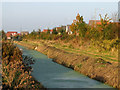
6
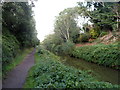
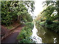
Towards the northern end of the canal, Bridgwater
This is the Bridgwater & Taunton canal north of Victoria Road.
Out of shot ahead, the canal enters locks connecting with the River Parrett.
Image: © Jaggery
Taken: 4 Oct 2012
0.16 miles
7
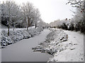
Bridgwater and Taunton Canal in winter
Image: © Ken Grainger
Taken: 18 Dec 2010
0.19 miles
8
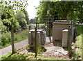
Substation by the canal
A substation with a number of components off Chatham Avenue.
Image: © Neil Owen
Taken: 17 Jun 2014
0.20 miles
9
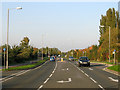
Northern Distributor Road, Bridgwater
Otherwise known as Homberg Way.
Image: © Ken Grainger
Taken: 12 Oct 2008
0.20 miles
10
Canal north of Victoria Road, Bridgwater
Looking along the Bridgwater & Taunton canal path towards a ramp up to Lyndale Avenue
Image: © Jaggery
Taken: 4 Oct 2012
0.20 miles