IMAGES TAKEN NEAR TO
Chidgey Close, BRIDGWATER, TA6 3JZ
Introduction
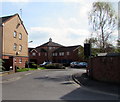
This page details the photographs taken nearby to Chidgey Close, TA6 3JZ by members of the Geograph project.
The Geograph project started in 2005 with the aim of publishing, organising and preserving representative images for every square kilometre of Great Britain, Ireland and the Isle of Man.

There are currently over 7.5m images from over14,400 individuals and you can help contribute to the project by visiting https://www.geograph.org.uk
Image Map (Loading...)


Getting Data...Please wait
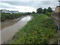
Leaflet Map data © OpenStreetMap
Images are licensed for reuse under creativecommons.org/licenses/by-sa/2.0
Notes
- Clicking on the map will re-center to the selected point.
- The higher the marker number, the further away the image location is from the centre of the postcode.
Image Listing (346 Images Found)
Images are licensed for reuse under creativecommons.org/licenses/by-sa/2.0
Image
Details
Distance
1
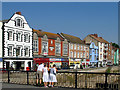
Bridgwater West Quay
Colourful row of buildings with some Dutch influence, seen from the River Parrett bridge
Image: © Ken Grainger
Taken: 4 Jul 2007
0.02 miles
2
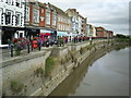
West Quay, Bridgwater from the old town bridge
This was once a working river frontage but has now been prettified.
Image: © Graham Hale
Taken: 7 Aug 2009
0.02 miles
3
Chidgey Close, Bridgwater
Chidgey Close is a cul-de-sac on the north side of Valetta Place.
Image: © Jaggery
Taken: 3 Apr 2017
0.03 miles
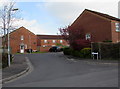
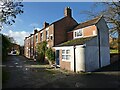
4
Bell Close, Bridgwater
Cul-de-sac on the west bank of the River Parrett, viewed from Northgate.
Image: © Jaggery
Taken: 3 Apr 2017
0.03 miles
5
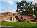
Remains of a glass cone
Northgate, Bridgwater
Image: © Ken Grainger
Taken: 13 Sep 2008
0.04 miles
7
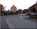
Valetta Place, Bridgwater
Valetta Place extends from Northgate to the west bank of the River Parrett out of shot ahead.
The Chidgey Close http://www.geograph.org.uk/photo/5344301 junction is on the left.
Image: © Jaggery
Taken: 3 Apr 2017
0.04 miles
8
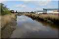
Downstream along the Parrett, Bridgwater
River Parrett viewed from Black Bridge. http://www.geograph.org.uk/photo/5353240
Image: © Jaggery
Taken: 3 Apr 2017
0.05 miles
9
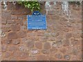
Plaque on wall of Crowpill Coal yard, Bridgwater
The civic society plaque records the use of the site for coal from South Wales and Forest of Dean, and notes that it was the last working site for Brunel's broad gauge track
Image: © David Smith
Taken: 5 Aug 2020
0.05 miles