IMAGES TAKEN NEAR TO
Riverside, BRIDGWATER, TA6 3HP
Introduction
This page details the photographs taken nearby to Riverside, TA6 3HP by members of the Geograph project.
The Geograph project started in 2005 with the aim of publishing, organising and preserving representative images for every square kilometre of Great Britain, Ireland and the Isle of Man.

There are currently over 7.5m images from over14,400 individuals and you can help contribute to the project by visiting https://www.geograph.org.uk
Image Map
Images are licensed for reuse under creativecommons.org/licenses/by-sa/2.0
Notes
- Clicking on the map will re-center to the selected point.
- The higher the marker number, the further away the image location is from the centre of the postcode.
Image Listing (406 Images Found)
Images are licensed for reuse under creativecommons.org/licenses/by-sa/2.0
Image
Details
Distance
1
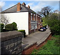
Valetta Place houses, Bridgwater
Semi-detached houses at the southeast edge of Valetta Place,
on the west bank of the River Parrett, below the western end of Black Bridge. http://www.geograph.org.uk/photo/5353274
Image: © Jaggery
Taken: 3 Apr 2017
0.00 miles
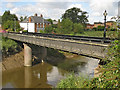
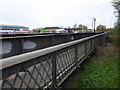
3
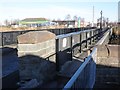
Western end of Black Bridge over the River Parrett, Bridgwater
See http://www.geograph.org.uk/photo/5353240 for another view of this Grade II (star) listed former telescopic railway bridge.
Image: © Jaggery
Taken: 3 Apr 2017
0.01 miles
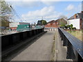
4

The 'Black Bridge', Bridgwater
A former steam powered telescopic railway bridge. Now fixed in position and used for pedestrian traffic.
Image: © Chris Allen
Taken: 14 Nov 2016
0.02 miles
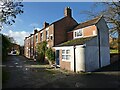
6
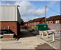
Electricity substation in a Bridgwater yard
The dark green cabinet is an electricity substation in a yard between Valetta Place and the road named The Clink. The substation identifier is DRAWBRIDGE SEW PUMP 213973.
Image: © Jaggery
Taken: 3 Apr 2017
0.02 miles
7
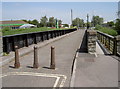
Black Bridge - a telescopic bridge
The old drawbridge, crossing the Parrett, used to carry plenty of docks trains in the past. The bridge would have been pulled out of the way for masted vessels passing underneath. There were columns supporting the lines with sections of rail capable of being moved on rollers and skids. Originally operated manually, steam power arrived later, with the engine house was located on the far side near the modern car wash. It was a busy bridge until the construction of the modern road bridge (The Clink) close by in the 1980s.
Black Bridge was built between 1850-99 and is a Grade II* listed structure.
Image: © Neil Owen
Taken: 17 Jun 2014
0.02 miles
8
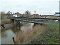
Bridgwater - The Black Bridge
Built in 1871 to carry a railway line across the river it is now a pedestrian bridge. The centre section could be pulled back to allow vessels to pass but has probably not worked since the 1920s. The steam plant survived into the early 1970s but has now been largely scrapped. Part of the mechanism does survive and the vertical boiler is preserved in a non-workable condition at Westonzoyland Pumping Station.
Image: © Chris Allen
Taken: 23 Feb 2013
0.03 miles
10
Black Bridge, Bridgwater
Built in 1871 this steam powered telescopic bridge carried the railway to the docks. It is now fixed in place and used only for pedestrians and cycles.
Image: © Chris Allen
Taken: 14 Nov 2016
0.03 miles