IMAGES TAKEN NEAR TO
West Quay, BRIDGWATER, TA6 3HL
Introduction
This page details the photographs taken nearby to West Quay, TA6 3HL by members of the Geograph project.
The Geograph project started in 2005 with the aim of publishing, organising and preserving representative images for every square kilometre of Great Britain, Ireland and the Isle of Man.

There are currently over 7.5m images from over14,400 individuals and you can help contribute to the project by visiting https://www.geograph.org.uk
Image Map (Loading...)


Getting Data...Please wait
Leaflet Map data © OpenStreetMap
Images are licensed for reuse under creativecommons.org/licenses/by-sa/2.0
Notes
- Clicking on the map will re-center to the selected point.
- The higher the marker number, the further away the image location is from the centre of the postcode.
Image Listing (554 Images Found)
Images are licensed for reuse under creativecommons.org/licenses/by-sa/2.0
Image
Details
Distance
1
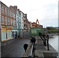
West Quay blocked, Bridgwater
Viewed in early October 2012. After the collapse of part of the River Parrett wall in West Quay, the road ahead is blocked for motor vehicles during repair work. The pavement gives pedestrians access to shops and businesses ahead, which remain open.
Image: © Jaggery
Taken: 4 Oct 2012
0.00 miles
2
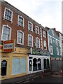
Green Olive Meze Restaurant, Bridgwater
Turkish cuisine restaurant in West Quay. A meze is a type of appetizer
or hors d'oeuvre often served with an aperitif before dinner.
Image: © Jaggery
Taken: 4 Oct 2012
0.00 miles
3
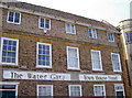
The Water Gate
Still looking a little jaded following a refurbishment but certainly better than of late.
Image: © Neil Owen
Taken: 5 Sep 2013
0.01 miles
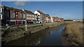
5
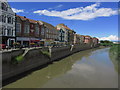
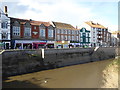
Bridgwater - River Parrett & West Quay as seen from Town Bridge
Image: © Colin Park
Taken: 6 Jul 2014
0.01 miles
6
West Quay, Bridgwater
Former quay side with mud berths on the river. There is still a surviving hand crane further along.
Image: © Chris Allen
Taken: 23 Feb 2013
0.01 miles
7
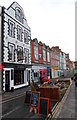
The Fountain pub, West Quay, Bridgwater
The town centre location is on the west bank of the River Parrett.
Image: © Jaggery
Taken: 4 Oct 2012
0.01 miles
8
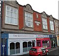
Fisherman's Wharf building, Bridgwater
The building is in West Quay on the west bank of the River Parrett. The year 1911 is above the FISHERMAN'S WHARF name on the wall. At the October 2012 date of this view, the upper floor was in use as flats. Below are The Gentleman's Room ("experiencing the art of modern and traditional male grooming") and American Nails (manicures, pedicures etc).
Image: © Jaggery
Taken: 4 Oct 2012
0.01 miles
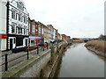
9
Waterfront buildings on West Quay Bridgwater
The tidal range of the River Parrett is clear from the markings on the river wall.
Image: © Rod Allday
Taken: 1 Nov 2014
0.01 miles
10
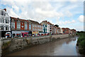
The River Parrett and West Quay, Bridgwater
View from the Eastover end of the Town Bridge.
Image: © habiloid
Taken: 9 Aug 2013
0.01 miles