IMAGES TAKEN NEAR TO
Alexandra Road, BRIDGWATER, TA6 3HE

Introduction

This page details the photographs taken nearby to Alexandra Road, TA6 3HE by members of the Geograph project.

The Geograph project started in 2005 with the aim of publishing, organising and preserving representative images for every square kilometre of Great Britain, Ireland and the Isle of Man.

There are currently over 7.5m images from over14,400 individuals and you can help contribute to the project by visiting https://www.geograph.org.uk

Image Map


Images are licensed for reuse under creativecommons.org/licenses/by-sa/2.0
Notes
  • Clicking on the map will re-center to the selected point.
  • The higher the marker number, the further away the image location is from the centre of the postcode.

Image Listing (167 Images Found)

Images are licensed for reuse under creativecommons.org/licenses/by-sa/2.0
  • ...
Image
Details
Distance
1
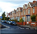
Alexandra Road
Image: © Roger Cornfoot Taken: 12 Nov 2016
0.01 miles
2
East side of Alexandra Road, Bridgwater
Alexandra Road is a cul-de-sac between the SE end of Victoria Road and allotments (ahead). The houses on this side of the road are in a long row, whereas those on the opposite side are semi-detached. http://www.geograph.org.uk/photo/3291103
Image: © Jaggery Taken: 4 Oct 2012
0.01 miles
3
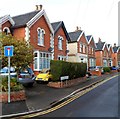
West side of Alexandra Road, Bridgwater
Alexandra Road is a cul-de-sac between the SE end of Victoria Road and allotments (ahead). The houses on this side of the road are semi-detached whereas those on the opposite side are in a long row. http://www.geograph.org.uk/photo/3291098
Image: © Jaggery Taken: 4 Oct 2012
0.02 miles
4
Ordnance Survey Cut Mark
This OS cut mark can be found on No13 Alexandra Road. It marks a point 12.686m above mean sea level.
Image: © Adrian Dust Taken: 16 Jan 2023
0.02 miles
5
The Maltshovel, Bridgwater
Another view of Image from North Street, with the mini roundabout at the corner of Wembdon Road and Alexandra Road. Most references to the pub seem to split the word in two, ie "malt shovel", but the sign clearly considers it one.
Image: © Derek Harper Taken: 26 Jan 2010
0.04 miles
6
The Maltshovel Inn
Image: © David Smith Taken: 14 Apr 2011
0.04 miles
7
The Malt shovel, Bridgwater
Image: © Chris Allen Taken: 14 Nov 2016
0.05 miles
8
Victoria Road Bridge, Bridgwater
And the Bridgwater and Somerset Canal
Image: © Ken Grainger Taken: 11 Mar 2007
0.05 miles
9
Bridge crest
The town crest is proudly positioned on a bridge in Victoria Street as the Bridgwater and Taunton Canal runs underneath it. Pity the pride doesn't extend to all the town folk.
Image: © Neil Owen Taken: 30 Aug 2012
0.05 miles
10
Camden Road, Bridgwater
Viewed across the A39 North Street.
Image: © Jaggery Taken: 4 Oct 2012
0.05 miles
  • ...