IMAGES TAKEN NEAR TO
High Street, BRIDGWATER, TA6 3BG
Introduction
This page details the photographs taken nearby to High Street, TA6 3BG by members of the Geograph project.
The Geograph project started in 2005 with the aim of publishing, organising and preserving representative images for every square kilometre of Great Britain, Ireland and the Isle of Man.

There are currently over 7.5m images from over14,400 individuals and you can help contribute to the project by visiting https://www.geograph.org.uk
Image Map (Loading...)


Getting Data...Please wait
Leaflet Map data © OpenStreetMap
Images are licensed for reuse under creativecommons.org/licenses/by-sa/2.0
Notes
- Clicking on the map will re-center to the selected point.
- The higher the marker number, the further away the image location is from the centre of the postcode.
Image Listing (455 Images Found)
Images are licensed for reuse under creativecommons.org/licenses/by-sa/2.0
Image
Details
Distance
1
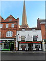
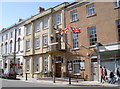
The Three Lions, Bridgwater
Pub at 29 High Street. Behind the pub is the spire of the Grade I listed Parish Church of St Mary. http://www.geograph.org.uk/photo/3309421
Image: © Jaggery
Taken: 4 Oct 2012
0.01 miles
2
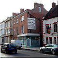
An old sign on a High Street wall, Bridgwater
The old sign, or perhaps a modern reproduction, is on the wall to the left of The Mansion House. http://www.geograph.org.uk/photo/3293401 The shop below the sign is empty and without a nameboard. The only relevant reference I can find is an entry in the London Gazette, where the partnership between Thomas Plowman and James John Trundle, carrying on business at Bridgwater in the county of Somerset as Saddlers and Harness Makers was dissolved by mutual consent. James John Trundle carried on the business on his own. The Gazette entry was dated July 2nd 1878.
Image: © Jaggery
Taken: 4 Oct 2012
0.01 miles
3
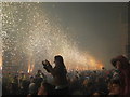
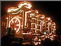
Looking west along Bridgwater High Street at the squibbing in 2014
Squibbing is unique to Bridgwater. It involves the simultaneous firing of lots of large fireworks ("squibs") and takes place at about 11.00pm, after the carnival procession has finished http://visitbridgwater.org/listings/view/45/Squibbing.
Image: © Rod Allday
Taken: 1 Nov 2014
0.01 miles
4
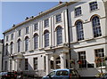
The Town Hall
Built in 1823 to plans drawn up by architect Richard Carver, Bridgwater Town Hall boasts the Charter Hall and the Auditorium, with seating for 445 people. See Image] for the neighbouring building.
Image: © Neil Owen
Taken: 30 Aug 2012
0.02 miles
5
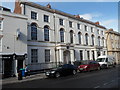
Bridgwater Town Hall
Located on the north side of High Street, the town hall was built in 1823 as the town's main municipal building. Its current use is as a multi-purpose public hall.
Image: © Jaggery
Taken: 4 Oct 2012
0.02 miles
6
Flags flying
Part of the Town Hall chambers of power in Bridgwater's High Street. See Image] for the next building.
Image: © Neil Owen
Taken: 30 Aug 2012
0.02 miles
9
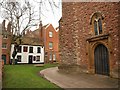
By St Mary's, Bridgwater
The west end of Image and Church Passage, with the rears of buildings that face onto the High Street.
Image: © Derek Harper
Taken: 26 Jan 2010
0.02 miles
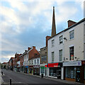
10
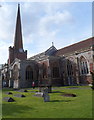
Grade I listed Parish Church of St Mary, Bridgwater
Viewed from Cornhill. There has been a church on this site since the start of the twelfth century.
The first vicar was recorded in 1170. There have been many changes and additions to the church
in the following centuries. It was substantially rebuilt in the 14th century and in the middle
of the 19th century. The vestry was built in 1902. In the early 1920s a memorial chapel was formed
to the south of the chancel in memory of the dead of the First World War.
Grade I listing (the highest category) was awarded in March 1950.
Image: © Jaggery
Taken: 4 Oct 2012
0.02 miles