IMAGES TAKEN NEAR TO
Charlynch, BRIDGWATER, TA5 2PF
Introduction
This page details the photographs taken nearby to TA5 2PF by members of the Geograph project.
The Geograph project started in 2005 with the aim of publishing, organising and preserving representative images for every square kilometre of Great Britain, Ireland and the Isle of Man.

There are currently over 7.5m images from over14,400 individuals and you can help contribute to the project by visiting https://www.geograph.org.uk
Image Map
Images are licensed for reuse under creativecommons.org/licenses/by-sa/2.0
Notes
- Clicking on the map will re-center to the selected point.
- The higher the marker number, the further away the image location is from the centre of the postcode.
Image Listing (7 Images Found)
Images are licensed for reuse under creativecommons.org/licenses/by-sa/2.0
Image
Details
Distance
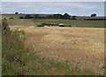
1
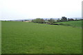
Crossmoor Farm
From the same spot as Image, looking to the right, across a harvested field.
Image: © Derek Harper
Taken: 26 Jul 2010
0.10 miles
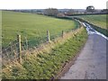
3
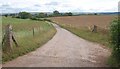
Track to Crossmoor Farm
Leading away from Charlynch Road into the valley of the Perrymoor Brook.
Image: © Derek Harper
Taken: 26 Jul 2010
0.12 miles
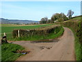
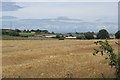
5
Barn near Crossmoor Farm
Looking along the line of footpath BW 30/53 as it leaves the Bridgwater-Spaxton road, across the upper Perrymoor Brook valley.
Image: © Derek Harper
Taken: 26 Jul 2010
0.21 miles