IMAGES TAKEN NEAR TO
Broomfield, BRIDGWATER, TA5 2EW
Introduction
This page details the photographs taken nearby to TA5 2EW by members of the Geograph project.
The Geograph project started in 2005 with the aim of publishing, organising and preserving representative images for every square kilometre of Great Britain, Ireland and the Isle of Man.

There are currently over 7.5m images from over14,400 individuals and you can help contribute to the project by visiting https://www.geograph.org.uk
Image Map
Images are licensed for reuse under creativecommons.org/licenses/by-sa/2.0
Notes
- Clicking on the map will re-center to the selected point.
- The higher the marker number, the further away the image location is from the centre of the postcode.
Image Listing (12 Images Found)
Images are licensed for reuse under creativecommons.org/licenses/by-sa/2.0
Image
Details
Distance
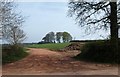
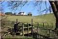
1
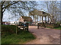
Rooks Castle Farm
This is where footpath BW 4/17 leaves the ridge road between Merridge and North Petherton to descend into the King's Cliff Stream valley. Beware the objectionable loose dog which threatens to savage you as you pass through the farmyard.
Image: © Derek Harper
Taken: 24 Apr 2010
0.04 miles
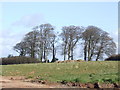
6
Clump of trees, Rooks Castle
A view from the same spot as Image, looking the other way. Footpath BW 17/7 passes through the gateway but keeps to the left of the clump of trees, which form part of the C18 planting of Halswell House's landscape park. The distant plantation, The Thickets, which is largely in Image, is much more recent and obscures the view of the trees from the north.
Image: © Derek Harper
Taken: 24 Apr 2010
0.13 miles
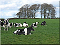
7
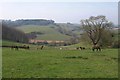
Grazing at Rooks Castle
Beasties at grass in a field crossed by footpath BW 4/17 as it drops down the slopes of the King's Cliff Stream valley. On the left is Rooks Castle Wood.
Image: © Derek Harper
Taken: 24 Apr 2010
0.15 miles
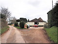
8
Copse by Rook's Castle Farm
A feature visible for miles around this southern end of the Quantock Hills.
Image: © Jonathan Billinger
Taken: 13 Mar 2007
0.15 miles
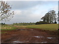
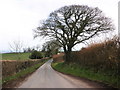
10
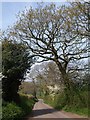
Ridge road near Rooks Castle Farm
The lane, here passing oaks coming into leaf, leads along high ground between between North Petherton and Merridge.
Image: © Derek Harper
Taken: 24 Apr 2010
0.23 miles