IMAGES TAKEN NEAR TO
Merridge, BRIDGWATER, TA5 1AZ
Introduction
This page details the photographs taken nearby to TA5 1AZ by members of the Geograph project.
The Geograph project started in 2005 with the aim of publishing, organising and preserving representative images for every square kilometre of Great Britain, Ireland and the Isle of Man.

There are currently over 7.5m images from over14,400 individuals and you can help contribute to the project by visiting https://www.geograph.org.uk
Image Map
Images are licensed for reuse under creativecommons.org/licenses/by-sa/2.0
Notes
- Clicking on the map will re-center to the selected point.
- The higher the marker number, the further away the image location is from the centre of the postcode.
Image Listing (22 Images Found)
Images are licensed for reuse under creativecommons.org/licenses/by-sa/2.0
Image
Details
Distance
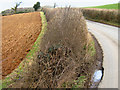
1
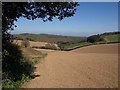
Tilled field above Holwell
The course of footpath BW 15/13 actually goes down the very foot of the valley that crosses this field, according to the maps, but, unusually, it is much faster to use the edge of the field, which here develops into a large triangular area that provides much easier walking. The minute dark specks in the green field on the extreme right are deer.
Image: © Derek Harper
Taken: 23 Apr 2010
0.10 miles
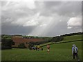
2
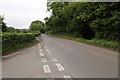
The road to Enmore and Bridgwater
From the Travellers Rest junction.
Image: © Peter Turner
Taken: 5 Sep 2016
0.12 miles
3
SCC Fingerpost near The Travellers Rest, Merridge
Image: © Andrew Riley
Taken: 6 Jun 2018
0.14 miles
4
Giant hedgehog on the roadside
Or maybe a freshly trimmed hedge.
Image: © Ken Grainger
Taken: 9 Mar 2009
0.15 miles
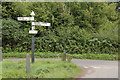
7
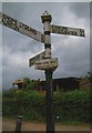
Old Direction Sign - Signpost near the Travellers Rest
Pyramid finial - 3 arms; Somerset SCC pyramid & name (Quantock Hills) by the UC road, in parish of Broomfield (Sedgemoor District), close to the Travellers Rest public house, in the centre of the T junction of Merridge Hill and Enmore Lane.
surveyed
Milestone Society National ID: SO_ST2133
Image: © Milestone Society
Taken: Unknown
0.16 miles
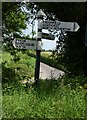
8

Old Direction Sign - Signpost near the Travellers Rest
Located close to the Travellers Rest public house, in the centre of the T junction of Merridge Hill and Enmore Lane. On the boundary of Broomfield and Spaxton parishes. 3 arms and pyramid finial. See https://www.geograph.org.uk/photo/6045235 for an older photo and https://www.geograph.org.uk/photo/5113858.
Milestone Society National ID: SO_ST2133
Image: © J Dowding
Taken: 20 May 2023
0.16 miles
9
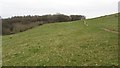
Path, Broomfield Hill
Broomfield Hill is covered in a large unenclosed grassland which is in the care of the National Trust. The path contours a steep grassy hillside.
Image: © Richard Webb
Taken: 31 Mar 2012
0.16 miles