IMAGES TAKEN NEAR TO
Seven Ash, TAUNTON, TA4 3EY
Introduction
This page details the photographs taken nearby to Seven Ash, TA4 3EY by members of the Geograph project.
The Geograph project started in 2005 with the aim of publishing, organising and preserving representative images for every square kilometre of Great Britain, Ireland and the Isle of Man.

There are currently over 7.5m images from over14,400 individuals and you can help contribute to the project by visiting https://www.geograph.org.uk
Image Map
Images are licensed for reuse under creativecommons.org/licenses/by-sa/2.0
Notes
- Clicking on the map will re-center to the selected point.
- The higher the marker number, the further away the image location is from the centre of the postcode.
Image Listing (16 Images Found)
Images are licensed for reuse under creativecommons.org/licenses/by-sa/2.0
Image
Details
Distance
1
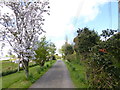
Channel to Channel (432)
The walk proceeds along this farm access road towards Kennel Lane and the A358.
Image: © Shazz
Taken: 30 Apr 2015
0.02 miles
2
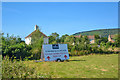
Combe Florey : Grassy Field
A field and an advertising sign.
Image: © Lewis Clarke
Taken: 12 Jul 2019
0.06 miles
3
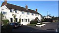
Seven Ash
The Old Stag's Head is still marked as a pub by the Ordnance Survey so must have closed recently. It is now a bed and breakfast.
Image: © Richard Webb
Taken: 1 Apr 2012
0.07 miles
4
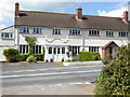
Channel to Channel (433)
Across the A358 from Kennel Lane is a former public house. See http://www.geograph.org.uk/photo/2885700 from 2012.
Image: © Shazz
Taken: 30 Apr 2015
0.07 miles
5
Channel to Channel (431)
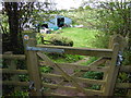
The path reaches a gate and steps with a barn ahead.
Image: © Shazz
Taken: 30 Apr 2015
0.08 miles
6
Buildings at Seven Ash
A lane that forms a triangle with the A358 (see Image) and the lane to Treble's Holford. I suppose this might once have been the main road.
Image: © Derek Harper
Taken: 25 Apr 2009
0.08 miles
7
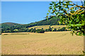
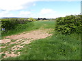
Combe Florey : Field
Looking out across the countryside.
Image: © Lewis Clarke
Taken: 12 Jul 2019
0.09 miles
8
Channel to Channel (434)
Having crossed the A358 and turned right the way ahead is marked as a dead end.
Image: © Shazz
Taken: 30 Apr 2015
0.09 miles
9

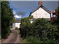
Channel to Channel (435)
The route carries on west past these cottages.
Image: © Shazz
Taken: 30 Apr 2015
0.12 miles
10
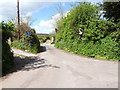
Channel to Channel (430)
The footpath crosses another and continues west.
Image: © Shazz
Taken: 30 Apr 2015
0.14 miles