IMAGES TAKEN NEAR TO
Wiveliscombe, TAUNTON, TA4 2SL
Introduction
This page details the photographs taken nearby to TA4 2SL by members of the Geograph project.
The Geograph project started in 2005 with the aim of publishing, organising and preserving representative images for every square kilometre of Great Britain, Ireland and the Isle of Man.

There are currently over 7.5m images from over14,400 individuals and you can help contribute to the project by visiting https://www.geograph.org.uk
Image Map (Loading...)


Getting Data...Please wait
Leaflet Map data © OpenStreetMap
Images are licensed for reuse under creativecommons.org/licenses/by-sa/2.0
Notes
- Clicking on the map will re-center to the selected point.
- The higher the marker number, the further away the image location is from the centre of the postcode.
Image Listing (11 Images Found)
Images are licensed for reuse under creativecommons.org/licenses/by-sa/2.0
Image
Details
Distance
1
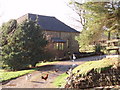
Old Holcombe Water Farm
This barn close to the old farmhouse, is newly converted. The farm is on a south facing slope some way off the B3224. A really beautiful spot to live.
Image: © Barbara Cook
Taken: 11 Jan 2006
0.03 miles
2
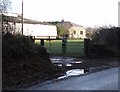
Holcombe Water Farm
On the North side of the B3224, Holcombe Water Farm has extensive barns and a smart new house which is possibly a barn conversion.
Image: © Barbara Cook
Taken: 11 Jan 2006
0.11 miles
3
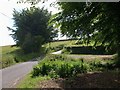
Holcombe Water
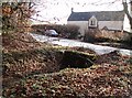
One might expect "Holcombe Water" to refer to the stream crossed beside this lane junction, but the maps indicate that it is the name of the place. The right turn is a bridleway to Fryan Farm; another bridleway and a footpath meet the parish boundary at this (obviously locally significant) spot.
Image: © Derek Harper
Taken: 25 Jun 2010
0.14 miles
5
Cottage
The road, the B3224, forms the southernmost boundary of Exmoor National Park, which the photographer standing in. The cottage would have originally been a farmworkers cottage as there are no nearby villages.
Image: © Barbara Cook
Taken: 11 Jan 2006
0.16 miles
6
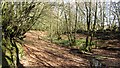
Holcombe
Woodland beside a brook which feeds Clatworthy Reservoir. Here, near the source, the water flows through deep leaf litter under beech trees.
Image: © Richard Webb
Taken: 1 Apr 2012
0.20 miles
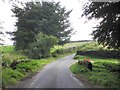
7
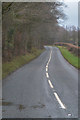
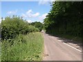
West Somerset : The B3224
Heading along the B3224.
Image: © Lewis Clarke
Taken: 18 Mar 2019
0.21 miles
8
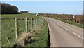
B3224, Holcombe Water
The Brendon ridge road is an old drovers route and the gap between its hedges is often wide. Here the road has been fenced creating a narrow field from the roadside strip. The hedge can be seen in the background.
Image: © Richard Webb
Taken: 1 Apr 2012
0.23 miles
9
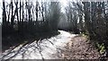
B3224 near Holcombe Water
The B road here forms the boundary of the Exmoor National Park (right), as well as the parish boundary between Brompton Ralph (left) and Elworthy (right). On the right is just a line of trees.
Image: © Derek Harper
Taken: 25 Jun 2010
0.23 miles
10
A Brendon green tunnel
Some of the big beech hedges which are common up here.
Image: © Richard Webb
Taken: 1 Apr 2012
0.23 miles