IMAGES TAKEN NEAR TO
Skilgate, TAUNTON, TA4 2DN
Introduction
This page details the photographs taken nearby to TA4 2DN by members of the Geograph project.
The Geograph project started in 2005 with the aim of publishing, organising and preserving representative images for every square kilometre of Great Britain, Ireland and the Isle of Man.

There are currently over 7.5m images from over14,400 individuals and you can help contribute to the project by visiting https://www.geograph.org.uk
Image Map (Loading...)


Getting Data...Please wait
Leaflet Map data © OpenStreetMap
Images are licensed for reuse under creativecommons.org/licenses/by-sa/2.0
Notes
- Clicking on the map will re-center to the selected point.
- The higher the marker number, the further away the image location is from the centre of the postcode.
Image Listing (10 Images Found)
Images are licensed for reuse under creativecommons.org/licenses/by-sa/2.0
Image
Details
Distance
1
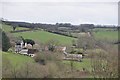
West Somerset : Surridge Farm & Surroundings
Looking towards Surridge Farm on the edge of Exmoor.
Image: © Lewis Clarke
Taken: 17 Mar 2012
0.01 miles
2
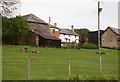
Skilgate: Surridge Farm
The building nearest the camera was apparently a water-powered saw mill. The leat has long since been ploughed up and the millpond is now a small copse. To left of the building a large overshot waterwheel survived in 1996, in an overgrown wheelpit
Image: © Martin Bodman
Taken: 25 May 1996
0.03 miles
5
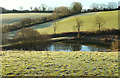
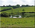
Pond near Skilgate
On a tributary of the Ben Brook, and visible on the left of Image
Image: © Derek Harper
Taken: 2 Dec 2019
0.14 miles
7
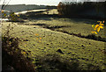
Stream near Skilgate
From where Image] was taken, looking left down the frosty valley, as the stream reaches a pond. Above this is Skilgate Wood, across the Ben Brook valley.
Image: © Derek Harper
Taken: 2 Dec 2019
0.19 miles
8

Valley near Skilgate
Image: © Derek Harper
Taken: 2 Dec 2019
0.20 miles
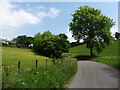
9

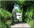
Lane and wood near Skilgate
Looking the other way from Image] as the lane turns a bend below the unnamed wood.
Image: © Derek Harper
Taken: 2 Dec 2019
0.23 miles
10

Track into wood near Skilgate
To the left of the scene in Image
Image: © Derek Harper
Taken: 2 Dec 2019
0.23 miles