IMAGES TAKEN NEAR TO
Churchinford, TAUNTON, TA3 7PS
Introduction
This page details the photographs taken nearby to TA3 7PS by members of the Geograph project.
The Geograph project started in 2005 with the aim of publishing, organising and preserving representative images for every square kilometre of Great Britain, Ireland and the Isle of Man.

There are currently over 7.5m images from over14,400 individuals and you can help contribute to the project by visiting https://www.geograph.org.uk
Image Map
Images are licensed for reuse under creativecommons.org/licenses/by-sa/2.0
Notes
- Clicking on the map will re-center to the selected point.
- The higher the marker number, the further away the image location is from the centre of the postcode.
Image Listing (5 Images Found)
Images are licensed for reuse under creativecommons.org/licenses/by-sa/2.0
Image
Details
Distance
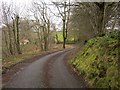
1
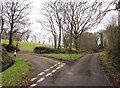
Lane junction near Higher Southey Farm
Past the grass triangle, Buttle's Lane continues up to the plateau and Buttle's Cross. The left turn is to Cleve Farm. This is an obscure part of the Blackdown Hills on the Somerset / Devon border, but quite well populated.
Image: © Derek Harper
Taken: 25 Feb 2012
0.07 miles
4
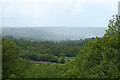
Churchstanton: overlooking the Bolham valley
Looking south west with rain falling on the far hill
Image: © Martin Bodman
Taken: 23 May 2006
0.22 miles
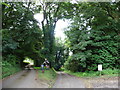
5
Lane past Heather Cottage
The lane shown on the left of Image winds along the crest of the valley of the Bolham River.
Image: © Derek Harper
Taken: 25 Feb 2012
0.25 miles