IMAGES TAKEN NEAR TO
Culmhead, TAUNTON, TA3 7EE
Introduction
This page details the photographs taken nearby to TA3 7EE by members of the Geograph project.
The Geograph project started in 2005 with the aim of publishing, organising and preserving representative images for every square kilometre of Great Britain, Ireland and the Isle of Man.

There are currently over 7.5m images from over14,400 individuals and you can help contribute to the project by visiting https://www.geograph.org.uk
Image Map
Images are licensed for reuse under creativecommons.org/licenses/by-sa/2.0
Notes
- Clicking on the map will re-center to the selected point.
- The higher the marker number, the further away the image location is from the centre of the postcode.
Image Listing (34 Images Found)
Images are licensed for reuse under creativecommons.org/licenses/by-sa/2.0
Image
Details
Distance
1
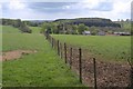
Otterford from the north
The hamlet, simply a church with adjoining large farm, lies in the shallow upper valley of the River Otter on the Blackdown Hills plateau. A footpath, T20/11, follows the other side of the fence into the churchyard; the tower of Image, in the centre, is largely obscured by a tree. In the background are the plantations around Otterford Lakes.
Image: © Derek Harper
Taken: 15 May 2010
0.01 miles
3
Otterford: St Leonard?s church
Looking south-south-east. The church and Church Farm form an isolated nucleus for the parish, not even qualifying as a hamlet
Image: © Martin Bodman
Taken: 21 Jul 2006
0.01 miles
4
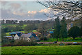
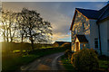
Otterford : Village Scenery
Looking down towards the hamlet of Otterford.
Image: © Lewis Clarke
Taken: 12 Jan 2020
0.01 miles
5
Otterford : Country Lane
A small lane heads through Otterford.
Image: © Lewis Clarke
Taken: 12 Jan 2020
0.02 miles
7
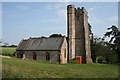
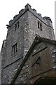
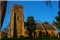
St Leonard?s church, Otterford
A view of Image from the southwest. Originally C14, the church has been much restored http://www.imagesofengland.org.uk/Details/Default.aspx?id=271218&mode=adv .
Image: © Derek Harper
Taken: 15 May 2010
0.02 miles
8
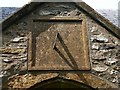
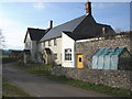
Sundial, Otterford church
This sundial over the porch door of Image is dated 1826 and inscribed cheerily "'Our days on the earth are as a shadow" http://www.imagesofengland.org.uk/Details/Default.aspx?id=271218&mode=adv .
Image: © Derek Harper
Taken: 15 May 2010
0.02 miles
9
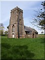
Otterford : St Leonard's Church
The church was built in the 14th century on the site of an earlier church. In 1158 Henry of Blois, the Bishop of Winchester, granted the Chapel of Otriforde to the Taunton Priory. The church underwent Victorian restoration in 1860. The parish is part of the Blackdown benefice within the Diocese of Bath and Wells.
Image: © Lewis Clarke
Taken: 12 Jan 2020
0.02 miles
10
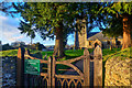
Otterford : St Leonard's Church
Entrance into the churchyard.
Image: © Lewis Clarke
Taken: 12 Jan 2020
0.02 miles