IMAGES TAKEN NEAR TO
Wrantage, TAUNTON, TA3 6DN
Introduction
This page details the photographs taken nearby to TA3 6DN by members of the Geograph project.
The Geograph project started in 2005 with the aim of publishing, organising and preserving representative images for every square kilometre of Great Britain, Ireland and the Isle of Man.

There are currently over 7.5m images from over14,400 individuals and you can help contribute to the project by visiting https://www.geograph.org.uk
Image Map
Images are licensed for reuse under creativecommons.org/licenses/by-sa/2.0
Notes
- Clicking on the map will re-center to the selected point.
- The higher the marker number, the further away the image location is from the centre of the postcode.
Image Listing (12 Images Found)
Images are licensed for reuse under creativecommons.org/licenses/by-sa/2.0
Image
Details
Distance
1
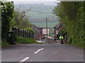
The hill down to the Somerset Levels at Rock
Image: © Rob Purvis
Taken: 6 May 2010
0.15 miles
2
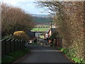
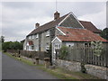
Rock Hill
Cottages on the lane descending the lias scarp from Image Behind, beyond a small enclave of western Sedgemoor, is part of the village of North Curry.
Image: © Derek Harper
Taken: 3 Mar 2007
0.15 miles
3
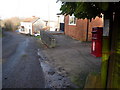
Rock: postbox № TA3 574
This small postbox is emptied finally at 12:30pm on weekdays and 45 minutes earlier on Saturdays.
Image: © Chris Downer
Taken: 24 Jan 2009
0.15 miles
4
Upnor Down
Half way up (or down) Rock Hill.
Image: © Roger Cornfoot
Taken: 15 Jul 2015
0.15 miles
6
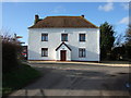
House at Rock
A smartly painted house at a lane junction at Rock, north of Curry Mallet.
Image: © Derek Harper
Taken: 3 Mar 2007
0.20 miles
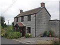
7
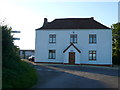
House at Rock
This house is on the road junction where the minor road down Rock Hill from Rock to West Sedgemoor crosses the minor road from Crimson Hill at the head of the Wrantage Inclined Plane to Fivehead. It would appear that at one time this road passed just to the right of this house but it has now been diverted and displaced about 40m east and so the junction is now staggered.
Image: © Nigel Mykura
Taken: 22 Jul 2012
0.20 miles
9
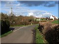
Lane junction at Rock
Another view of the junction seen in Image, with Rock Hill joining on the left.
Image: © Derek Harper
Taken: 3 Mar 2007
0.21 miles
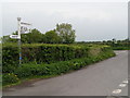
10
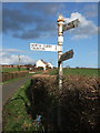
Signpost at Rock
"North Curry" lies down Rock Hill, the lane that descends the Lias scarp from this junction. In the background are the buildings shown in Image; the lane runs along the crest of the scarp.
Image: © Derek Harper
Taken: 3 Mar 2007
0.21 miles