IMAGES TAKEN NEAR TO
Channon Road, TAUNTON, TA2 8GT
Introduction
This page details the photographs taken nearby to Channon Road, TA2 8GT by members of the Geograph project.
The Geograph project started in 2005 with the aim of publishing, organising and preserving representative images for every square kilometre of Great Britain, Ireland and the Isle of Man.

There are currently over 7.5m images from over14,400 individuals and you can help contribute to the project by visiting https://www.geograph.org.uk
Image Map
Images are licensed for reuse under creativecommons.org/licenses/by-sa/2.0
Notes
- Clicking on the map will re-center to the selected point.
- The higher the marker number, the further away the image location is from the centre of the postcode.
Image Listing (12 Images Found)
Images are licensed for reuse under creativecommons.org/licenses/by-sa/2.0
Image
Details
Distance
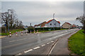
3
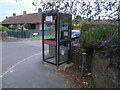
Telephone kiosk at Monkton Heathfield
This is No 29 of 42 images of BT telephone boxes in Taunton Deane which BT is trying to cull due to their claimed 'lack of use'.
Image: © Nick Mutton 01329 000000
Taken: 28 Jun 2008
0.14 miles
4
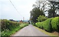
Willows, Monkton Heathfield
The grey weather seems to rather suit these attractive willows along Dyer’s Brook, a tributary of the Tone. The short lane is the one mentioned in Image, wgich links the A3259 and the A38, and turns sharply left where it meets the trees. Those trees to the right of the willows are across a gridline in Image, as is the house on Richard Crescent.
Image: © Derek Harper
Taken: 9 Oct 2009
0.18 miles
5
Sidbrook, near Monkton Heathfield
An area of scattered houses on the north eastern fringe of Taunton
Image: © Barbara Cook
Taken: 6 May 2006
0.20 miles
6
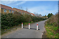
Monkton Heathfield : Hob Lane
Hob Lane is closed to traffic.
Image: © Lewis Clarke
Taken: 9 Mar 2019
0.21 miles
7
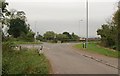
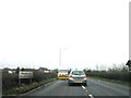
Crossroads, A3259
This is by Proctor's - now Prockter's - Farm. The lane from West Monkton reaches the main road between Monkton Elm and Monkton Heathfield (to the right) and continues on the far side to the nearby A38.
Image: © Derek Harper
Taken: 9 Oct 2009
0.21 miles
8
Monkton Heathfield : Yallards Hill A3259
A road heading through Monkton Heathfield.
Image: © Lewis Clarke
Taken: 9 Mar 2019
0.21 miles
9
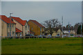
Monkton Heathfield : Bawler Road
New housing at Monkton Heathfield.
Image: © Lewis Clarke
Taken: 9 Mar 2019
0.22 miles
10
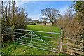
Taunton Deane : Grassy Field
A gate provides entrance into the field.
Image: © Lewis Clarke
Taken: 9 Mar 2019
0.23 miles