IMAGES TAKEN NEAR TO
Selworthy, MINEHEAD, TA24 8TR
Introduction
This page details the photographs taken nearby to TA24 8TR by members of the Geograph project.
The Geograph project started in 2005 with the aim of publishing, organising and preserving representative images for every square kilometre of Great Britain, Ireland and the Isle of Man.

There are currently over 7.5m images from over14,400 individuals and you can help contribute to the project by visiting https://www.geograph.org.uk
Image Map (Loading...)


Getting Data...Please wait
Leaflet Map data © OpenStreetMap
Images are licensed for reuse under creativecommons.org/licenses/by-sa/2.0
Notes
- Clicking on the map will re-center to the selected point.
- The higher the marker number, the further away the image location is from the centre of the postcode.
Image Listing (133 Images Found)
Images are licensed for reuse under creativecommons.org/licenses/by-sa/2.0
Image
Details
Distance

2
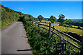
Selworthy : Country Lane
A small lane heading out from the village.
Image: © Lewis Clarke
Taken: 17 Sep 2019
0.02 miles
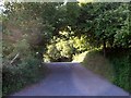
3
Footpath to Brakeley Steps
This footpath strikes off to the south just to the east of Selworthy Church (see Image]) - curiously it is not marked as such on the OS maps which shows the footpath leaving the lane some distance to the west.
Image: © Rob Farrow
Taken: 29 May 2007
0.02 miles


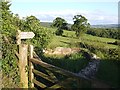
6
Entrance to NT car park, Selworthy
This lane leads into the National Trust Car Park at Selworthy. From here the village straggles downhill, starting with the church (see Image] & Image]) and leading to the very picturesque cottages around the green. (see various photos for square SS9145)
Image: © Rob Farrow
Taken: 29 May 2007
0.03 miles
7
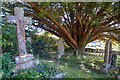
Selworthy : Church of All Saints Ground
Headstones underneath the tree.
Image: © Lewis Clarke
Taken: 17 Sep 2019
0.03 miles
8
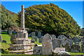
Selworthy: churchyard cross
Looking east in All Saints churchyard with an old yew tree beyond
Image: © Martin Bodman
Taken: 5 Sep 2007
0.03 miles
9
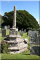
Selworthy : Church of All Saints Ground
The headstones and site of a former cross can be seen here.
Image: © Lewis Clarke
Taken: 17 Sep 2019
0.03 miles
10
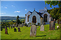
Selworthy : Church of All Saints
The Church of All Saints which sits on a hillside above Selworthy, Somerset, England is a whitewashed 15th-century Church, with a 14th-century tower. It has been designated by English Heritage as a Grade I listed building.
Image: © Lewis Clarke
Taken: 17 Sep 2019
0.03 miles